Earthquakes and tsunami – WJEC Case study: Japan tsunami 2011 (HIC)
Earthquakes are caused by the release of built-up pressure at plate boundaries. They can destroy buildings and infrastructure. Tsunami can also occur, with equally devastating and deadly effects.
Part of Geography Tectonic landscapes and hazards

Case study: Japan tsunami 2011 (HIC)
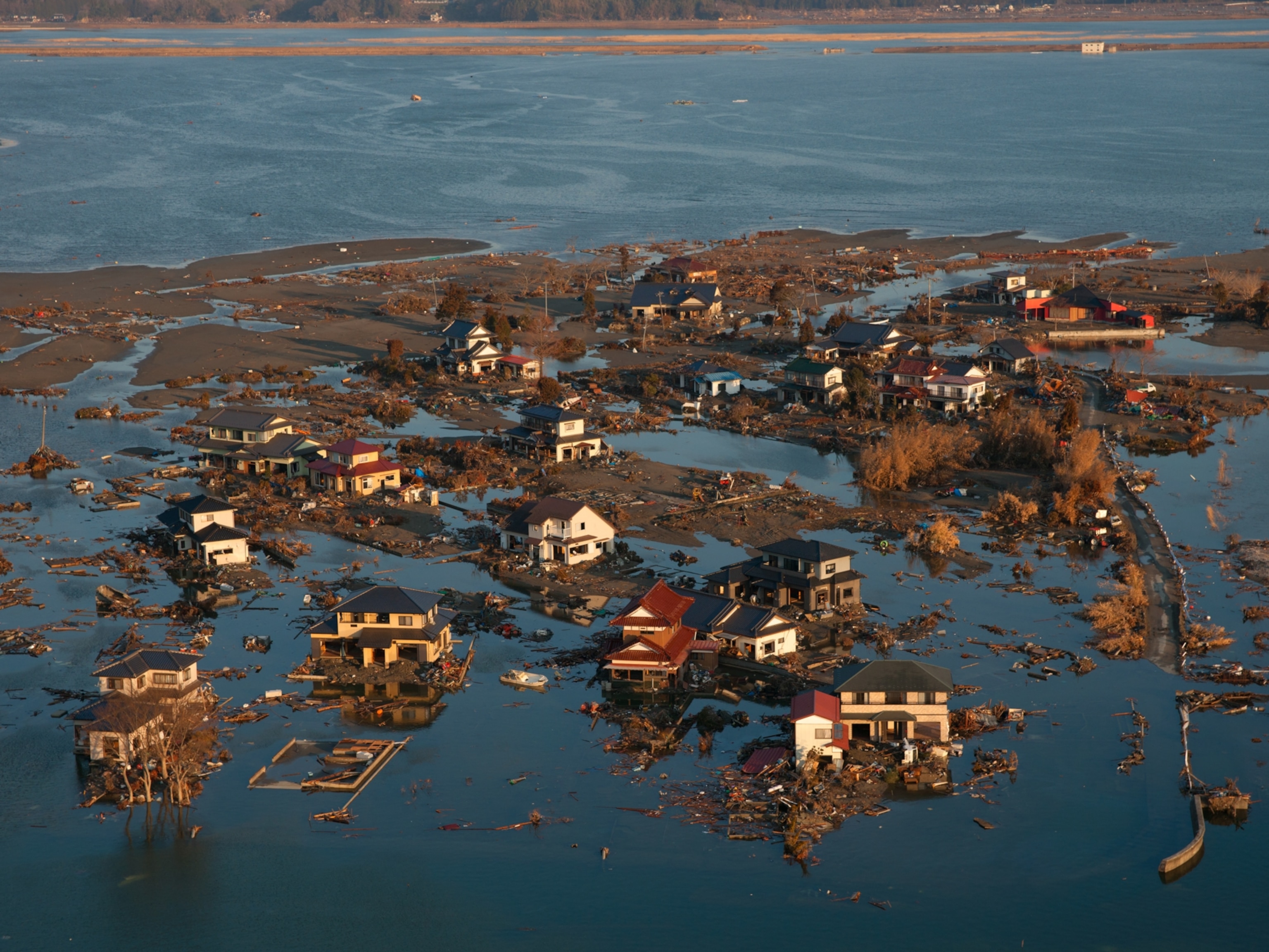
On Friday 11 March 2011 at 14:46:24, an earthquake of magnitude nine on the Richter scale close Richter scale The measure by which the strength of earthquakes is determined. occurred. It was at the point where the Pacific tectonic plate slides beneath the North American plate. The epicentre close epicentre The point on the Earth's surface directly above the focus of an earthquake. was 30 kilometres below the Pacific Ocean seabed and 129 kilometres off the east coast of Honshu, Japan. This triggered a tsunami. High, powerful waves were generated and travelled across the Pacific Ocean. The area worst affected by the tsunami was the east coast of Honshu in Japan.
Main impacts
Infrastructure.
- The waves travelled as far as ten kilometres inland in Sendai.
- Ports and airports in Sendai were damaged and closed.
- The waves destroyed protective tsunami seawalls at several locations.
- The massive surge destroyed three-storey buildings where people had gathered for safety.
- A state of emergency was declared at the Fukushima nuclear power plant, where a cooling system failed and released radioactive materials into the environment.
- In July 2013, the Tokyo Electric Power Company (TEPCO), admitted that about 300 tons of radioactive water continued to leak from the plant every day into the Pacific Ocean.
Social and economic
- Four years after the quake, around 230,000 people who lost their homes were still living in temporary housing.
- The total damages from the earthquake and tsunami are estimated at $300 billion (about 25 trillion yen).
- The number of confirmed deaths as of 10 April 2015 is 15,891. More than 2,500 people are still reported missing.
Responses to build capacity to reduce the risk
- The country unveiled a newly-installed, upgraded tsunami warning system in 2013.
- Earthquake engineers examined the damage, looking for ways to construct buildings that are more resistant to earthquakes and tsunamis. Studies are ongoing.
More guides on this topic
- Plate tectonic theory – WJEC
- Volcanoes – WJEC
- Reducing the impacts of natural hazards – WJEC
Related links
- Geography: Exam practice
- Personalise your Bitesize!
- Jobs that use Geography
- BBC Weather
- Revision Buddies Subscription
- The Royal Geographical Society
- Seneca Learning

Case Study: How does Japan live with earthquakes?
Japan lies within one of the most tectonically active zones in the world. It experiences over 400 earthquakes every day. The majority of these are not felt by humans and are only detected by instruments. Japan has been hit by a number of high-intensity earthquakes in the past. Since 2000 there are have been 16000 fatalities as the result of tectonic activity.
Japan is located on the Pacific Ring of Fire, where the North American, Pacific, Eurasian and Philippine plates come together. Northern Japan is on top of the western tip of the North American plate. Southern Japan sits mostly above the Eurasian plate. This leads to the formation of volcanoes such as Mount Unzen and Mount Fuji. Movements along these plate boundaries also present the risk of tsunamis to the island nation. The Pacific Coastal zone, on the east coast of Japan, is particularly vulnerable as it is very densely populated.
The 2011 Japan Earthquake: Tōhoku
Japan experienced one of its largest seismic events on March 11 2011. A magnitude 9.0 earthquake occurred 70km off the coast of the northern island of Honshu where the Pacific and North American plate meet. It is the largest recorded earthquake to hit Japan and is in the top five in the world since records began in 1900. The earthquake lasted for six minutes.

A map to show the location of the 2011 Japan Earthquake
The earthquake had a significant impact on the area. The force of the megathrust earthquake caused the island of Honshu to move east 2.4m. Parts of the Japanese coastline dr[[ed by 60cm. The seabed close to the focus of the earthquake rose by 7m and moved westwards between 40-50m. In addition to this, the earthquake shifted the Earth 10-15cm on its axis.
The earthquake triggered a tsunami which reached heights of 40m when it reached the coast. The tsunami wave reached 10km inland in some places.
What were the social impacts of the Japanese earthquake in 2011?
The tsunami in 2011 claimed the lives of 15,853 people and injured 6023. The majority of the victims were over the age of 60 (66%). 90% of the deaths was caused by drowning. The remaining 10% died as the result of being crushed in buildings or being burnt. 3282 people were reported missing, presumed dead.
Disposing of dead bodies proved to be very challenging because of the destruction to crematoriums, morgues and the power infrastructure. As the result of this many bodies were buried in mass graves to reduce the risk of disease spreading.
Many people were displaced as the result of the tsunami. According to Save the Children 100,000 children were separated from their families. The main reason for this was that children were at school when the earthquake struck. In one elementary school, 74 of 108 students and 10 out of 13 staff lost their lives.
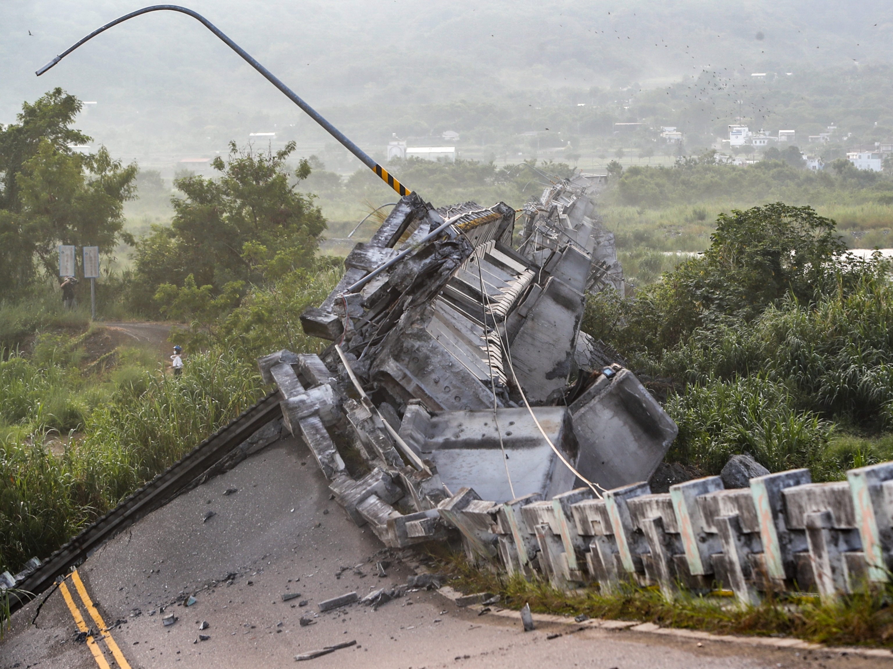
More than 333000 people had to live in temporary accommodation. National Police Agency of Japan figures shows almost 300,000 buildings were destroyed and a further one million damaged, either by the quake, tsunami or resulting fires. Almost 4,000 roads, 78 bridges and 29 railways were also affected. Reconstruction is still taking place today. Some communities have had to be relocated from their original settlements.
What were the economic impacts of the Japanese earthquake in 2011?
The estimated cost of the earthquake, including reconstruction, is £181 billion. Japanese authorities estimate 25 million tonnes of debris were generated in the three worst-affected prefectures (counties). This is significantly more than the amount of debris created during the 2010 Haiti earthquake. 47,700 buildings were destroyed and 143,300 were damaged. 230,000 vehicles were destroyed or damaged. Four ports were destroyed and a further 11 were affected in the northeast of Japan.
There was a significant impact on power supplies in Japan. 4.4 million households and businesses lost electricity. 11 nuclear reactors were shut down when the earthquake occurred. The Fukushima Daiichi nuclear power plant was decommissioned because all six of its reactors were severely damaged. Seawater disabled the plant’s cooling systems which caused the reactor cores to meltdown, leading to the release of radioactivity. Radioactive material continues to be released by the plant and vegetation and soil within the 30km evacuation zone is contaminated. Power cuts continued for several weeks after the earthquake and tsunami. Often, these lasted between 3-4 hours at a time. The earthquake also had a negative impact on the oil industry as two refineries were set on fire during the earthquake.
Transport was also negatively affected by the earthquake. Twenty-three train stations were swept away and others experienced damage. Many road bridges were damaged or destroyed.
Agriculture was affected as salt water contaminated soil and made it impossible to grow crops.
The stock market crashed and had a negative impact on companies such as Sony and Toyota as the cost of the earthquake was realised. Production was reduced due to power cuts and assembly of goods, such as cars overseas, were affected by the disruption in the supply of parts from Japan.
What were the political impacts of the Japanese earthquake in 2011?
Government debt was increased when it injects billions of yen into the economy. This was at a time when the government were attempting to reduce the national debt.
Several years before the disaster warnings had been made about the poor defences that existed at nuclear power plants in the event of a tsunami. A number of executives at the Fukushima power plant resigned in the aftermath of the disaster. A movement against nuclear power, which Japan heavily relies on, developed following the tsunami.
The disaster at Fukushima added political weight in European countries were anti-nuclear bodies used the event to reinforce their arguments against nuclear power.
Privacy Overview
Pin it on pinterest.
You must be logged in to post a comment.
- 0 Shopping Cart
Japan Earthquake 2011
Japan earthquake 2011 case study.
An earthquake measuring 9.0 on the Richter Scale struck off Japan’s northeast coast, about 250 miles (400km) from Tokyo at a depth of 20 miles.
The magnitude 9.0 earthquake happened at 2:46 pm (local time) on Friday, March 11, 2011.
The earthquake occurred 250 miles off the North East Coast of Japan’s main island Honshu.

Japan 2011 Earthquake map
Japan is located on the eastern edge of the Eurasian Plate. The Eurasian plate, which is continental, is subducted by the Pacific Plate, an oceanic plate forming a subduction zone to the east of Japan. This type of plate margin is known as a destructive plate margin . The process of subduction is not smooth. Friction causes the Pacific Plate to stick. Pressure builds and is released as an earthquake.
Friction has built up over time, and when released, this caused a massive ‘megathrust’ earthquake.
The amount of energy released in this single earthquake was 600 million times the energy of the Hiroshima nuclear bomb.
Scientists drilled into the subduction zone soon after the earthquake and discovered a thin, slippery clay layer lining the fault. The researchers think this clay layer allowed the two plates to slide an incredible distance, some 164 feet (50 metres), facilitating the enormous earthquake and tsunami .

2011 Japan Earthquake Map
The earthquake occurred at a relatively shallow depth of 20 miles below the surface of the Pacific Ocean. This, combined with the high magnitude, caused a tsunami (find out more about how a tsunami is formed on the BBC website).
Areas affected by the 2011 Japanese earthquake.
What were the primary effects of the 2011 Japan earthquake?
Impacts on people
Death and injury – Some 15,894 people died, and 26,152 people were injured. 130,927 people were displaced, and 2,562 remain missing.
Damage – 332,395 buildings, 2,126 roads, 56 bridges and 26 railways were destroyed or damaged. 300 hospitals were damaged, and 11 were destroyed.
Blackouts – Over 4.4 million households were left without electricity in North-East Japan.
Transport – Japan’s transport network suffered huge disruptions.
Impacts on the environment
Landfall – some coastal areas experienced land subsidence as the earthquake dropped the beachfront in some places by more than 50 cm.
Land movement – due to tectonic shift, the quake moved parts of North East Japan 2.4 m closer to North America.
Plate shifts – It has been estimated by geologists that the Pacific plate has slipped westwards by between 20 and 40 m.
Seabed shift – The seabed near the epicentre shifted by 24 m, and the seabed off the coast of the Miyagi province has moved by 3 m.
Earth axis moves – The earthquake moved the earth’s axis between 10 and 25 cm, shortening the day by 1.8 microseconds.
Liquefaction occurred in many of the parts of Tokyo built on reclaimed land. 1,046 buildings were damaged
What were the secondary effects of the 2011 Japan earthquake?
Economy – The earthquake was the most expensive natural disaster in history, with an economic cost of US$235 billion.
Tsunami – Waves up to 40 m in high devastated entire coastal areas and resulted in the loss of thousands of lives. This caused a lot of damage and pollution up to 6 miles inland. The tsunami warnings in coastal areas were only followed by 58% who headed for higher ground. The wave hit 49% of those not following the warning.
Nuclear power – Seven reactors at the Fukushima nuclear power station experienced a meltdown. Levels of radiation were over eight times the normal levels.
Transport – Rural areas remained isolated for a long time because the tsunami destroyed major roads and local trains and buses. Sections of the Tohoku Expressway were damaged. Railway lines were damaged, and some trains were derailed.
Aftermath – The ‘Japan move forward committee’ thought that young adults and teenagers could help rebuild parts of Japan devastated by the earthquake.
Coastal changes – The tsunami was able to travel further inland due to a 250-mile stretch of coastline dropping by 0.6 m.
What were the immediate responses to the Japan 2011 earthquake?
- The Japan Meteorological Agency issued tsunami warnings three minutes after the earthquake.
- Scientists had been able to predict where the tsunami would hit after the earthquake using modelling and forecasting technology so that responses could be directed to the appropriate areas.
- Rescue workers and around 100,000 members of the Japan Self-Defence Force were dispatched to help with search and rescue operations within hours of the tsunami hitting the coast.
- Although many search and rescue teams focused on recovering bodies washing up on shore following the tsunami, some people were rescued from under the rubble with the help of sniffer dogs.
- The government declared a 20 km evacuation zone around the Fukushima nuclear power plant to reduce the threat of radiation exposure to local residents.
- Japan received international help from the US military, and search and rescue teams were sent from New Zealand, India, South Korea, China and Australia.
- Access to the affected areas was restricted because many were covered in debris and mud following the tsunami, so it was difficult to provide immediate support in some areas.
- Hundreds of thousands of people who had lost their homes were evacuated to temporary shelters in schools and other public buildings or relocated to other areas.
- Many evacuees came from the exclusion zone surrounding the Fukushima nuclear power plant. After the Fukushima Daiichi nuclear meltdown, those in the area had their radiation levels checked, and their health monitored to ensure they did not receive dangerous exposure to radiation. Many evacuated from the area around the nuclear power plant were given iodine tablets to reduce the risk of radiation poisoning.
What were the long-term responses to the Japan 2011 earthquake?
- In April 2011, one month after the event occurred, the central government established the Reconstruction Policy Council to develop a national recovery and reconstruction outlook for tsunami-resilient communities. The Japanese government has approved a budget of 23 trillion yen (approximately £190 billion) to be spent over ten years. Central to the New Growth Strategy is creating a ‘Special Zones for Reconstruction’ system. These aim to provide incentives to attract investment, both in terms of business and reconstruction, into the Tohoku region.
- Also, the central government decided on a coastal protection policy, such as seawalls and breakwaters which would be designed to ensure their performance to a potential tsunami level of up to the approximately 150-year recurrence interval.
- In December 2011, the central government enacted the ‘Act on the Development of Tsunami-resilient Communities’. According to the principle that ‘Human life is most important, this law promotes the development of tsunami-resistant communities based on the concept of multiple defences, which combines infrastructure development and other measures targeting the largest class tsunami.
- Japan’s economic growth after the Second World War was the world’s envy. However, over the last 20 years, the economy has stagnated and been in and out of recession. The 11 March earthquake wiped 5–10% off the value of Japanese stock markets, and there has been global concern over Japan’s ability to recover from the disaster. The priority for Japan’s long-term response is to rebuild the infrastructure in the affected regions and restore and improve the economy’s health as a whole.
- By the 24th of March 2011, 375 km of the Tohoku Expressway (which links the region to Tokyo) was repaired and reopened.
- The runway at Sendai Airport had been badly damaged. However, it was restored and reusable by the 29th of March due to a joint effort by the Japanese Defence Force and the US Army.
- Other important areas of reconstruction include the energy, water supply and telecommunications infrastructure. As of November 2011, 96% of the electricity supply had been restored, 98% of the water supply and 99% of the landline network.
Why do people live in high-risk areas in Japan?
There are several reasons why people live in areas of Japan at risk of tectonic hazards:
- They have lived there all their lives, are close to family and friends and have an attachment to the area.
- The northeast has fertile farmland and rich fishing waters.
- There are good services, schools and hospitals.
- 75% of Japan is mountainous and flat land is mainly found in coastal areas, which puts pressure on living space.
- They are confident about their safety due to the protective measures that have been taken, such as the construction of tsunami walls.
Japan’s worst previous earthquake was of 8.3 magnitude and killed 143,000 people in Kanto in 1923. A magnitude 7.2 quake in Kobe killed 6,400 people in 1995 .

Premium Resources
Please support internet geography.
If you've found the resources on this page useful please consider making a secure donation via PayPal to support the development of the site. The site is self-funded and your support is really appreciated.
Related Topics
Use the images below to explore related GeoTopics.
Previous Topic Page
Topic home, next topic page, share this:.
- Click to share on Twitter (Opens in new window)
- Click to share on Facebook (Opens in new window)
- Click to share on Pinterest (Opens in new window)
- Click to email a link to a friend (Opens in new window)
- Click to share on WhatsApp (Opens in new window)
- Click to print (Opens in new window)
If you've found the resources on this site useful please consider making a secure donation via PayPal to support the development of the site. The site is self-funded and your support is really appreciated.
Search Internet Geography
Top posts and pages.
Latest Blog Entries
Pin It on Pinterest
- Click to share
- Print Friendly
- International edition
- Australia edition
- Europe edition

Japan earthquake and tsunami: what happened and why
What caused the tsunami.
The most powerful earthquake recorded in Japanese history, magnitude 8.9. The tremors were the result of a violent uplift of the sea floor 80 miles off the coast of Sendai, where the Pacific tectonic plate slides beneath the plate Japan sits on. Tens of miles of crust ruptured along the trench where the tectonic plates meet. The earthquake occurred at the relatively shallow depth of 15 miles, meaning much of its energy was released at the seafloor.
How does the earthquake compare with others?
This was the sixth largest earthquake in the world since 1900, when seismological records began. The most devastating earthquake to strike Japan was in 1923, when a magnitude 7.9 tremor devastated Tokyo and Yokohama and killed an estimated 142,800 people. The Kobe earthquake in 1995 was a magnitude 6.9 and caused more than 5,000 deaths and injured 36,000 others. The earthquake that wrecked Christchurch in New Zealand last month was a magnitude 6.3 event. Around 30 times more energy is released as the magnitude of an earthquake increases one unit, for example from magnitude 8 to 9.
Why is the area so prone to earthquakes?
The Pacific plate moves fast in tectonic terms, at a rate of 9cm (3.5 inches) a year. This leads to the rapid buildup of huge amounts of energy. As the Pacific plate moves down, it sticks to the overhead plate and pulls it down too. Eventually, the join breaks, causing the seafloor to spring upwards several metres. The plate tectonics of the region are complex, and geologists are not sure which plate Japan sits on. Candidates include the Eurasian plate, the North American plate, the Okhotsk plate, and the Honshu microplate.
How big were the waves?
The largest waves measured by instruments in the water were 7 metres (nearly 23ft) high in the north-east of Japan, according to the Pacific Tsunami Warning Centre (PTWC) in Hawaii. Other estimates put the wave height at 10 metres. Waves reached 4 metres around the coast of Japan. As the tsunami spread across the Pacific, the wave height dropped to around 40cm in Guam and the nearby Marianas. The most powerful waves appeared to be moving south-west from Japan. Some countries may experience waves up to 2 metres, according to PTWC forecasts.
How much damage has been caused?
Japan has invested heavily in coastal protection and buildings that can withstand tremors. Nevertheless, ports were pounded by the tsunami and the airport in Sendai was inundated. Nuclear power plants were shut down across the country and a state of emergency declared at the Fukushima nuclear power plant, where a cooling system failed. Modern buildings in Japan are designed to absorb the violent sideways shaking that can devastate cities. High-rise buildings can still be damaged, but are more likely to remain standing. There are concerns for low-lying islands in the Pacific.
How long will the waves take to reach other countries?
The tsunami moves across the Pacific at a speed of 500mph, with waves expected to reach the island of Fiji and Cairns in Australia at 3.28pm GMT. From then, waves are due to reach Acapulco in Mexico at 7.59pm, Chile at 10.55pm, Ecuador at 11.31pm, Colombia at 11.47 and Peru at 12.33am.
Will there be aftershocks?
Regular aftershocks have already hit Japan as the Earth's crust continues to rupture along the Japan trench. Those tremors are expected to be weaker and are less likely to produce another tsunami. The release of energy along the subduction zone between the Pacific and North Atlantic plates will transfer stress to other parts of the faultline, which could easily generate more earthquakes in the region in coming months.
- Natural disasters and extreme weather
- Asia Pacific
- Earthquakes
Most viewed

A ship washed ashore during the 2011 Japan tsunami lies amidst wreckage in Kesennuma, Miyagi, Japan.
The 2011 Japan Tsunami Was Caused By Largest Fault Slip Ever Recorded
Clay lubricated the fault zone in the Japan trench, producing the devastating tsunami, researchers say.
The largest fault slip ever recorded produced the devastating 2011 Japan tsunami , according to three studies published today.
Two years ago, the sea off the coast of Japan reared up and swept away tens of thousands of lives in a devastating natural disaster.
The 2011 earthquake has been the subject of intense study ever since, and the trench that produced it is the best studied in the world. (See " Japan Tsunami: 20 Unforgettable Pictures .")
Now, three papers published today in the journal Science reveal the magnitude 9 earthquake off the east coast of Japan still has the capacity to surprise.
Experts calculate the fault—or the boundary between two tectonic plates—in the Japan trench slipped by as much as 164 feet (50 meters). Other similarly large magnitude earthquakes, including the 9.1 Sumatra event in 2004, resulted in a 66-to-82 foot (20-to-25 meter) slip in the fault.
"We've never seen 50-meter [slips]," said Kelin Wang, a geophysicist with the Geological Survey of Canada in British Columbia.
The next largest slip would probably be the Chile earthquake in 1960, said Wang, who was not involved in the research. Based on the limited data recorded from that earthquake, the fault slipped by 98 to 131 feet (30 to 40 meters).
Most of the movement occurred horizontally, he explained. But because the plates are wedged together at this trench, that horizontal displacement still managed to thrust up enough seawater to produce the killer tsunami that hit Japan.
Greasing The Wheels
Lubrication, specifically involving clay, is the key to such massive movement, said Frederick Chester , a geophysicist at Texas A & M University in College Station, and lead author of one of the studies .
The two tectonic plates involved are the Pacific plate, on which the Pacific Ocean resides, and a portion of the North American plate , on which parts of Japan sit.
A thick layer of clay sits atop the Pacific plate, which is getting dragged under a portion of the North American plate. As the Pacific plate dives into a trench off the coast of Japan, small portions of the clay get smeared along the plate boundary, Chester explained.
That clay traps water, rendering it quite slippery, he said. "We think that's responsible for allowing the incredibly large slip we observed near the trench."
Normally, when two plates collide, there is friction. You can think of friction like a brake, Chester explained. "But clay almost removes any braking properties."
Not a Lot of Heat
The unprecedented data haul that enabled Chester and colleagues to figure out what happened during the 2011 earthquake is courtesy of a rapid response by the Japan Agency for Marine-Earth Science and Technology, said Emily Brodsky , a geophysicist at the University of California, Santa Cruz, and a co-author of one of the studies.
The Japan Trench Fast Drilling project enabled researchers to get out to the fault zone about a year after the earthquake and drop instruments down to measure temperature anomalies—the sudden slips during an earthquake can generate vast amounts of heat—and to bring up samples of the fault zone itself for analysis.
Experts were able to take core samples of sediment and rock from the trench—located in 23,000 feet (7,000 meters) of water—thanks to a sophisticated drilling ship.
"[This] was right at the edge of what engineering could do," Brodsky said.
Not only did they find evidence of this thin layer of lubricating clay, but experts were also able calculate how much heat and friction was involved.
Even though the earthquake produced a 1,100° to 2,200°F (600° to 1,200°C) temperature increase, the amount of friction that had to be overcome to produce the fault slip wasn't as large as researchers expected, said Brodsky.
This helped confirm the fact that something else was going on—namely the clay lubrication.
It's difficult to say whether something like this could happen elsewhere, said Wang, because no other submarine trench has as many instruments monitoring it.
"Nowhere else do we have such a massive monitoring system."
Follow Jane J. Lee on Twitter .
For Hungry Minds
Related topics.
- EARTHQUAKES
You May Also Like
Japan's 2011 megaquake left a scar at the bottom of the sea. Scientists finally explored it.
What causes earthquakes?

3,600-year-old tsunami ‘time capsule’ sheds light on one of humanity’s greatest disasters

A tsunami could wipe this Norwegian town off the map. Why isn’t everyone leaving?
A huge volcano near Naples has been convulsing. What does it mean?
- Environment
History & Culture
- History & Culture
- History Magazine
- Mind, Body, Wonder
- Coronavirus Coverage
- Paid Content
- Terms of Use
- Privacy Policy
- Your US State Privacy Rights
- Children's Online Privacy Policy
- Interest-Based Ads
- About Nielsen Measurement
- Do Not Sell or Share My Personal Information
- Nat Geo Home
- Attend a Live Event
- Book a Trip
- Inspire Your Kids
- Shop Nat Geo
- Visit the D.C. Museum
- Learn About Our Impact
- Support Our Mission
- Advertise With Us
- Customer Service
- Renew Subscription
- Manage Your Subscription
- Work at Nat Geo
- Sign Up for Our Newsletters
- Contribute to Protect the Planet
Copyright © 1996-2015 National Geographic Society Copyright © 2015-2024 National Geographic Partners, LLC. All rights reserved
COMMENTS
Location: The earthquake struck 250 miles off the northeastern coast of Japan's Honshu Island at 2:46 pm (local time) on March 11, 2011. Japan 2011 Earthquake map. Magnitude: It measured 9.1 on the Moment Magnitude scale, making it one of the most powerful earthquakes ever recorded. Japan is a highly developed country with advanced ...
Case study: Japan tsunami 2011 (HIC) On Friday 11 March 2011 at 14:46:24, an earthquake of magnitude nine on the Richter scale close Richter scale The measure by which the strength of earthquakes ...
A massive tsunami, generated by a powerful undersea earthquake, breaching the seawall at Miyako, Japan, March 11, 2011. (more) The magnitude-9.0 earthquake struck at 2:46 pm. (The early estimate of magnitude 8.9 was later revised upward.) The epicentre was located some 80 miles (130 km) east of the city of Sendai, Miyagi prefecture, and the ...
Case Study: How does Japan live with earthquakes? Japan lies within one of the most tectonically active zones in the world. It experiences over 400 earthquakes every day. ... The tsunami in 2011 claimed the lives of 15,853 people and injured 6023. The majority of the victims were over the age of 60 (66%). 90% of the deaths was caused by ...
What were the primary effects of the 2011 Japan earthquake? Impacts on people. Death and injury - Some 15,894 people died, and 26,152 people were injured. 130,927 people were displaced, and 2,562 remain missing. Damage - 332,395 buildings, 2,126 roads, 56 bridges and 26 railways were destroyed or damaged. 300 hospitals were damaged, and 11 ...
We revisited the lessons of the 2011 Great East Japan Earthquake Tsunami disaster specifically on the response and impact, ... Throughout the case study in Sendai city, the proposed reconstruction plan was evaluated from the tsunami engineering point of view to discuss how the post 2011 paradigm was implemented in coastal communities for future ...
The most devastating earthquake to strike Japan was in 1923, when a magnitude 7.9 tremor devastated Tokyo and Yokohama and killed an estimated 142,800 people. The Kobe earthquake in 1995 was a ...
The 2011 Tōhoku earthquake and tsunami had a great environmental impact on Japan's eastern coast. The rarity and magnitude of the earthquake-tsunami prompted researchers Jotaro Urabe , Takao Suzuki, Tatsuki Nishita, and Wataru Makino to study their immediate ecological impacts on intertidal flat communities at Sendai Bay and the Sanriku Ria coast.
plate (USGS, 2011). This region of Japan has a well-documented his- tory of earthquakes, including at least 32 ranging from 7 to mid-mag- nitude 8 since 1900 (NGDC, 2011). The Tohoku sequence began on March 9 with a magnitude 7.3 earth- quake that was widely felt. The Japan Meteorological Agency (JMA) issued a tsunami warning for the
The Tsunami Began in Northern Japan. On March 11, 2011, a 9.1 earthquake occurred near Japan, shifting the earth 200 feet along a fault line under the sea. The epicenter was located 45 miles east of the city of Sendai out in the Pacific Ocean. It was almost 3:00 in the afternoon when the earthquake started, and the shaking lasted for 6 minutes.
On 11 March 2011, a 9.0 magnitude earthquake off the north-eastern coast of Japan - the strongest ever recorded in the country - triggered a tsunami up to 30 metres high that washed up to 5 kilometres inland. It resulted in massive loss of life, environmental devastation and infrastructural damage. The disaster also damaged several nuclear power plants, leading to serious risks of ...
The case of the Great East Japan Earthquake and Tsunami of 2011. HelpAge International East Asia/Pacific Regional Office 6 Soi 17, Nimmanhaemin Road Suthep, Muang, Chiang Mai 50200, Thailand Tel ...
A significant leak occurred in August 2013 that was severe enough to prompt Japan's Nuclear Regulation Authority to classify it as a level-3 nuclear incident. Japan earthquake and tsunami of 2011 - Aftermath, Recovery, Rebuilding: The number of those confirmed dead or listed as missing was about 18,500. Most of those killed were drowning ...
The 2011 earthquake has been the subject of intense study ever since, and the trench that produced it is the best studied in the world. (See " Japan Tsunami: 20 Unforgettable Pictures .")
Members of the Japanese Ground Self-Defense Force in rescue and recovery operations in Ōfunato, Iwate prefecture, Japan, after the city was devastated by the March 11, 2011, earthquake and tsunami. In the first hours after the earthquake, Japanese Prime Minister Kan Naoto moved to set up an emergency command centre in Tokyo, and a large number ...
Case study examining the causes of the Tohoku 2011 Earthquake that hit Japan in 2011 and measured 8.9 on the Richter scale. It was the largest earthquake to ...
Part IV Case studies: Africa; Part V Case studies: the Middle East; Part VI Case studies: Asia and the Pacific Region; 21 The Chao Phraya floods 2011; 22 Environmental risk management in Australia: natural hazards; 23 The 2008 Wenchuan, China, earthquake; 24 The 2011 Tohoku, Japan, earthquake and tsunami; 25 India's tsunami warning system
Sanriku tsunami events. Second, we revisit the responses to the 2011 event, specifically on the tsunami warning system and efforts to identify the tsunami impacts and lessons learned. Third, the post-disaster paradigm shifts in reconstruction are discussed through a case study in Sendai city, Miyagi prefecture. 2. Pre-2011paradigm
1. Introduction [2] On March 11, 2011, the 2011 Tohoku-Oki earthquake occurred off the Pacific coast of northeastern Honshu, Japan. The event was a dip-slip rupture of the plate boundary between the Pacific and North America plates, and the moment magnitude (M W) of this event was 9.0, which is the largest value ever recorded in Japan.This gigantic event excited a huge tsunami, which struck ...
The tsunami Powerful as the earthquake's immediate impact was, its overwhelming effect was the creation of a devastating tsunami on Japan's north-east coast. A six metre upward surge of the seabed at the epicentre set up a wave that travelled at 800 km/h across the Pacific and westwards to Japan. As it approached Japan, the
This article presents a case study on tsunami risk assessment performed by Asahi Kasei Corporation, Japan, based on four steps: (1) review of Natech events caused by the 2011 Great East Japan Earthquake, (2) hazard identification at the plant, (3) risk assessment considering human casualties, equipment loss, environment, and business continuity ...
Title: Tohoku Earthquake and Tsunami 2011 - Case Study - World at Risk - Edexcel Geography IAL Created Date: 20191125163816Z
hit Japan in March 2011 involved a set of complex and interrelated factors, some physical and some of human origin. The result was perhaps the worst disaster to befall Japan since the Second World War. The seabed off the eastern coast of Japan is a highly seismologically active section of the earth's crust (Figure 1). The Eurasian, Pacific
Following the 2011 Tohoku earthquake and tsunami, disaster risk reduction using structural/non-structural coastal defence structures has gained momentum. These . ... A Case Study of Japan. 26 Pages Posted: 3 May 2024. See all articles by YUI OMORI YUI OMORI. Kyoto University. Koichi Kuriyama. Kyoto University.