- 0 Shopping Cart £ 0.00 -->


Hurricane Irma Case Study
Hurricane Irma is one of the most powerful hurricanes ever recorded over the Atlantic Ocean. The hurricane was so powerful that seismometers, machines used to detect the strength of earthquakes, detected it.
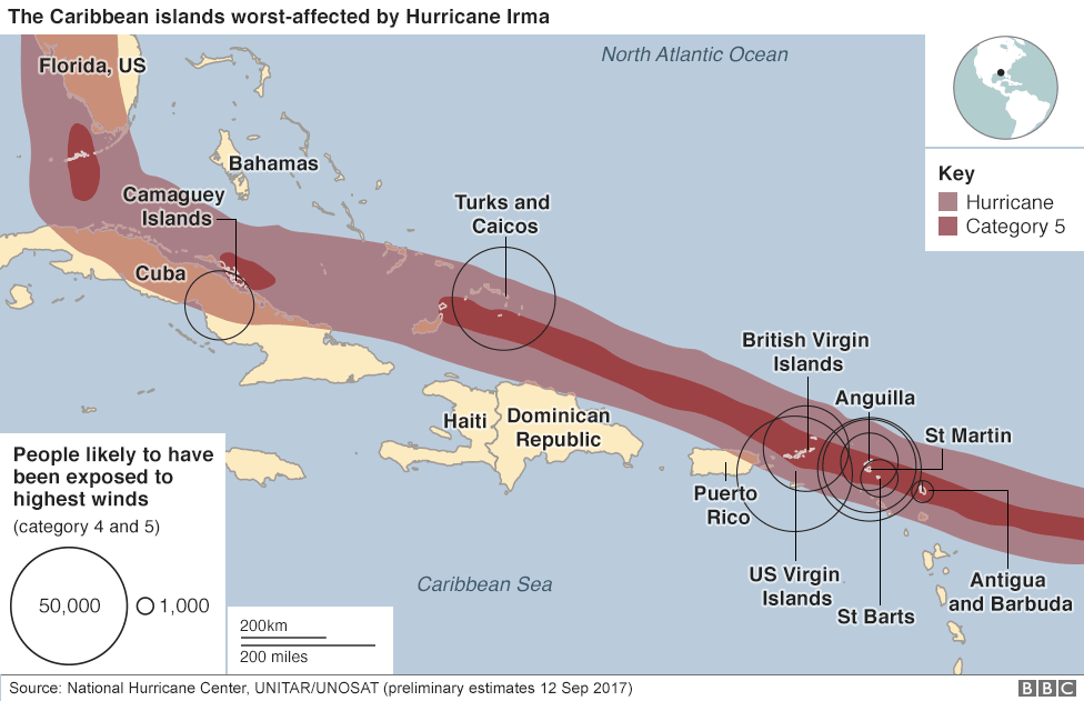
Hurricane Irma struck the Caribbean and the east coast of the United States in September 2017. The hurricane developed on 30th August near the Cape Verde Islands. High ocean temperatures and extremely low pressures over the Atlantic fuelled the storm’s intensity. The hurricane first made landfall on 6th September along the northern coast of Barbuda with wind speeds of up to 282 kph (175mph). It travelled north along the east coast of the Caribbean as a category-five hurricane. The hurricane reached Florida on 10th September as a category four hurricane with sustained winds of 209 kph (130mph).

Hurricane Irma – the path of destruction
Planning to manage the impact
Given that Irma’s forecast track was along much of the Caribbean island chain, hurricane warnings were issued for the northern Leeward Islands, Puerto Rico, and parts of Hispaniola on September 5.
On September 4, Puerto Rico declared a state of emergency. By September 6, the U.S. Federal Emergency Management Agency had deployed response teams in Puerto Rico and the United States Virgin Islands. Supplies, including food rations, medical supplies, and blankets, were pre-staged in strategic locations on the islands for distribution .
In the Turks and Caicos, evacuation orders were issued for low-lying areas starting September 5. Schools were closed, government buildings were boarded up, and shelters were opened. Officials spread warnings to residents in various languages via social media, radio, SMS, and WhatsApp.
The Dominican Republic activated the International Charter on Space and Major Disasters, thus providing for humanitarian satellite coverage; the United States and Haiti followed suit two days later. According to officials, 11,200 people were evacuated from vulnerable areas before the storm’s arrival. Seven thousand four hundred tourists were moved away from beach resorts to Santo Domingo.
In The Bahamas, the government began preparations the week before the hurricane’s arrival, including securing national sports facilities for shelter use. By September 7, the government had evacuated 1,609 people by air from the southern islands, including 365 from Bimini.
The US National Hurricane Centre issued several warnings for the Southeastern United States. The Civil Defense evacuated nearly one million people from low-lying areas before the storm.
Officials advised residents to stock their hurricane kits. Road tolls were suspended in Florida to enable more people to evacuate. Public schools, state colleges, and state universities in all 67 counties in Florida were closed between the 8th and 11th September. Almost 700 emergency shelters were opened throughout the state and used by almost 200,000 people. Main airports were closed. An estimated 6.5 million Floridians were ordered to evacuate, mostly those living on barrier islands or in coastal areas, in mobile or sub-standard homes, and in low-lying or flood-prone areas.
Primary Effects
Irma was the most intense hurricane to strike the east coast of the United States since Katrina in 2005. The hurricane resulted in 134 deaths and caused over $65 billion in damage. The northeastern Caribbean and Florida were worst hit. On the Caribbean island of Barbuda, 90% of all structures were damaged or destroyed. Hurricane Irma is the second-costliest Caribbean hurricane on record.
The island of Providenciales is a popular tourist destination, and dozens of holidaymakers were caught on the island, unable to leave before the hurricane hit.
People were forced to evacuate their cities to avoid Irma’s wake. People left their towns and homes to find safer places to ride out the storm. Some people stayed in shelters, while others visited family or friends out of the hurricane’s path.
On Sint Maarten, 95% of the houses there had been damaged, and 60% had been left uninhabitable.
It is estimated that Irma caused at least $50 billion in damage in Florida and led to 84 deaths. Cities like Miami and Jacksonville suffered flooding, and some 60% of homes across Florida were left without power. In Florida, inland areas like Immokalee experienced widespread flooding.
The highest recorded storm surge in the US was a 2.3m storm surge. Approximately 7.7 million electrical customers across Florida lost power at some point; this accounts for 73% of customers. Flooding occurred in over 30 rivers and creeks. Fifty thousand boats were destroyed or damaged.
In the Florida Keys, the hurricane caused significant damage to homes, buildings, trailer parks, boats, roads, the electricity supply, mobile phone coverage, internet access, sanitation, the water supply, and the fuel supply. Initially, it was estimated that about 25% of homes were destroyed, and 65% of others suffered extensive damage.
One hundred prisoners escaped jail in the British Virgin Islands.
Secondary Effects
Many Caribbean islands strongly rely on tourism and will continue to feel the economic impact of Irma for a long time into the future.
Research suggests that recovery to previous levels could take up to four years, and if this is the case, the region will miss out on over US$3 billion over this timeframe.
Due to the significant impact of several hurricanes during 2017, insurance companies such as Lloyds of London reported an annual loss in earnings.
Six months after Hurricane Irma, many in Puerto Rico still go to school and look after the elderly in the dark. There are still UK citizens sleeping in a government shelter with nowhere to call home on the Virgin Islands.
Immediate Response
The French and UK governments sent aid workers, food and medical equipment to their overseas territories to start the long process of reconstruction there.
£57 million pounds of funding, along with 120 tonnes of aid, was provided by the UK Government. British military troops, along with Department For International Development (DFID) logisticians, supported the restoration of electricity to the main power station on the British Virgin Islands as part of the ongoing recovery operation. Additionally, the UK government doubled any public donations made to the Red Cross appeal for the hurricane’s victims up to £3 million.
Six UK medical health experts have been deployed to Antigua to assess the capacity of healthcare provisions on affected islands in the region. 54 officers from forces around the UK carried out joint patrols of the islands and assisted in policing duties.
Two hundred and fifty Dutch troops were deployed on Sint Maarten to deliver aid, food, medical supplies and building materials – and to maintain security.
The five living former US presidents have raised more than $31m (£23.5m) for victims in the US.
Long-term Response
Coming in the future!

Premium Resources
Please support internet geography.
If you've found the resources on this page useful please consider making a secure donation via PayPal to support the development of the site. The site is self-funded and your support is really appreciated.

Related Topics
Use the images below to explore related GeoTopics.
Share this:
- Click to share on Twitter (Opens in new window)
- Click to share on Facebook (Opens in new window)
- Click to share on Pinterest (Opens in new window)
- Click to email a link to a friend (Opens in new window)
- Click to share on WhatsApp (Opens in new window)
- Click to print (Opens in new window)
If you've found the resources on this site useful please consider making a secure donation via PayPal to support the development of the site. The site is self-funded and your support is really appreciated.
Search Internet Geography
Latest Blog Entries
Pin It on Pinterest
- Click to share
- Print Friendly
- International
- Education Jobs
- Schools directory
- Resources Education Jobs Schools directory News Search

Hurricane Irma Case Study
Subject: Geography
Age range: 14-16
Resource type: Unit of work
Last updated
4 February 2021
- Share through email
- Share through twitter
- Share through linkedin
- Share through facebook
- Share through pinterest

A series of lessons including location, cause, preparation, effects and responses with an extended writing activity at the end of the unit.
The location lesson focuses on the path of the hurricane and includes a line of latitude and longitude activity. The cause lesson includes a video link and fill in the gap activity. The preparation lesson includes a card sort and explanation tasks. The effects lesson includes a venn diagram to categorise effects, explanation and evaluation of effects. The responses lesson includes a range of activities and an extended writing activity.
Tes paid licence How can I reuse this?
Your rating is required to reflect your happiness.
It's good to leave some feedback.
Something went wrong, please try again later.
This resource hasn't been reviewed yet
To ensure quality for our reviews, only customers who have purchased this resource can review it
Report this resource to let us know if it violates our terms and conditions. Our customer service team will review your report and will be in touch.
Not quite what you were looking for? Search by keyword to find the right resource:

IMAGES
VIDEO
COMMENTS
Irma was the most intense hurricane to strike the east coast of the United States since Katrina in 2005. The hurricane resulted in 134 deaths and caused over $65 billion in damage. The northeastern Caribbean and Florida were worst hit.
Describe the path of Hurricane Irma: Formed in the North Atlantic, went West over the Caribbean (especially the BVIs), right over the Bahamas and tilting North over Florida. Give three Social Primary Effects: - On Sint Maarten 95% of all houses were destroyed.
Study with Quizlet and memorise flashcards containing terms like Affected areas, Antigua and Barbuda (effects), Antigua and Barbuda (response) and others.
Long term responses include repairing infrastructure; restoring coastal wetlands; investing in new sea developments; and improving predictions and warnings. Study with Quizlet and memorize flashcards containing terms like When did Irma occur, Where did Irma hit, What caused Hurricane Irma and more.
Using Figure 4, describe the track of Hurricane Irma between 6 September 2017 and 12 September 2017. Answer: Credit use of direction, starting point, distances, dates and named locations. E.g. Hurricane had a change of direction [1] of W/WNW initially, then N/NNW [1].
Saffir-Simpson Hurricane Wind Scale. ‘Hurricane Irma hit several islands in the Caribbean on 6 September 2017, with devastating consequences for the local population. On Sint Maarten, it has so far resulted in eight deaths.
Hurricane Irma Case Study. A series of lessons including location, cause, preparation, effects and responses with an extended writing activity at the end of the unit. The location lesson focuses on the path of the hurricane and includes a line of latitude and longitude activity.
Study with Quizlet and memorize flashcards containing terms like when, where, area affected and more.
Case Study Research Project. Your task is to create a project on a single tropical cyclone. It can be a cyclone, typhoon or hurricane but it must have taken place within your lifetime. Your project can be electronic or hard copy and can be submitted in either format.
‘Hurricane Irma hit several islands in the Caribbean on 6 September 2017, with devastating consequences for the local population. On Sint Maarten, it has so far resulted in eight deaths.