

Bhuj Earthquake India 2001 – A Complete Study
Bhuj earthquake india.

Gujarat : Disaster on a day of celebration : 51st Republic Day on January 26, 2001
- 7.9 on the Richter scale.
- 8.46 AM January 26th 2001
- 20,800 dead
Basic Facts
- Earthquake: 8:46am on January 26, 2001
- Epicenter: Near Bhuj in Gujarat, India
- Magnitude: 7.9 on the Richter Scale
Geologic Setting
- Indian Plate Sub ducting beneath Eurasian Plate
- Continental Drift
- Convergent Boundary
Specifics of 2001 Quake
Compression Stress between region’s faults
Depth: 16km
Probable Fault: Kachchh Mainland
Fault Type: Reverse Dip-Slip (Thrust Fault)
The earthquake’s epicentre was 20km from Bhuj. A city with a population of 140,000 in 2001. The city is in the region known as the Kutch region. The effects of the earthquake were also felt on the north side of the Pakistan border, in Pakistan 18 people were killed.
Tectonic systems
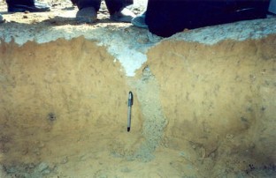
The earthquake was caused at the convergent plate boundary between the Indian plate and the Eurasian plate boundary. These pushed together and caused the earthquake. However as Bhuj is in an intraplate zone, the earthquake was not expected, this is one of the reasons so many buildings were destroyed – because people did not build to earthquake resistant standards in an area earthquakes were not thought to occur. In addition the Gujarat earthquake is an excellent example of liquefaction, causing buildings to ‘sink’ into the ground which gains a consistency of a liquid due to the frequency of the earthquake.
India : Vulnerability to earthquakes
- 56% of the total area of the Indian Republic is vulnerable to seismic activity .
- 12% of the area comes under Zone V (A&N Islands, Bihar, Gujarat, Himachal Pradesh, J&K, N.E.States, Uttaranchal)
- 18% area in Zone IV (Bihar, Delhi, Gujarat, Haryana, Himachal Pradesh, J&K, Lakshadweep, Maharashtra, Punjab, Sikkim, Uttaranchal, W. Bengal)
- 26% area in Zone III (Andhra Pradesh, Bihar, Goa, Gujarat, Haryana, Kerala, Maharashtra, Orissa, Punjab, Rajasthan, Tamil Nadu, Uttaranchal, W. Bengal)
- Gujarat: an advanced state on the west coast of India.
- On 26 January 2001, an earthquake struck the Kutch district of Gujarat at 8.46 am.
- Epicentre 20 km North East of Bhuj, the headquarter of Kutch.
- The Indian Meteorological Department estimated the intensity of the earthquake at 6.9 Richter. According to the US Geological Survey, the intensity of the quake was 7.7 Richter.
- The quake was the worst in India in the last 180 years.
What earthquakes do
- Casualties: loss of life and injury.
- Loss of housing.
- Damage to infrastructure.
- Disruption of transport and communications.
- Breakdown of social order.
- Loss of industrial output.
- Loss of business.
- Disruption of marketing systems.
- The earthquake devastated Kutch. Practically all buildings and structures of Kutch were brought down.
- Ahmedabad, Rajkot, Jamnagar, Surendaranagar and Patan were heavily damaged.
- Nearly 19,000 people died. Kutch alone reported more than 17,000 deaths.
- 1.66 lakh people were injured. Most were handicapped for the rest of their lives.
- The dead included 7,065 children (0-14 years) and 9,110 women.
- There were 348 orphans and 826 widows.
Loss classification
Deaths and injuries: demographics and labour markets
Effects on assets and GDP
Effects on fiscal accounts
Financial markets
Disaster loss
- Initial estimate Rs. 200 billion.
- Came down to Rs. 144 billion.
- No inventory of buildings
- Non-engineered buildings
- Land and buildings
- Stocks and flows
- Reconstruction costs (Rs. 106 billion) and loss estimates (Rs. 99 billion) are different
- Public good considerations
Human Impact: Tertiary effects
- Affected 15.9 million people out of 37.8 in the region (in areas such as Bhuj, Bhachau, Anjar, Ganhidham, Rapar)
- High demand for food, water, and medical care for survivors
- Humanitarian intervention by groups such as Oxfam: focused on Immediate response and then rehabilitation
- Of survivors, many require persistent medical attention
- Region continues to require assistance long after quake has subsided
- International aid vital to recovery
Social Impacts

- 80% of water and food sources were destroyed.
- The obvious social impacts are that around 20,000 people were killed and near 200,000 were injured.
- However at the same time, looting and violence occurred following the quake, and this affected many people too.
- On the other hand, the earthquake resulted in millions of USD in aid, which has since allowed the Bhuj region to rebuild itself and then grow in a way it wouldn’t have done otherwise.
- The final major social effect was that around 400,000 Indian homes were destroyed resulting in around 2 million people being made homeless immediately following the quake.
Social security and insurance
- Ex gratia payment: death relief and monetary benefits to the injured
- Major and minor injuries
- Cash doles
- Government insurance fund
- Group insurance schemes
- Claim ratio
Demographics and labour market
- Geographic pattern of ground motion, spatial array of population and properties at risk, and their risk vulnerabilities.
- Low population density was a saving grace.
- Extra fatalities among women
- Effect on dependency ratio
- Farming and textiles

Economic Impacts
- Total damage estimated at around $7 billion. However $18 billion of aid was invested in the Bhuj area.
- Over 15km of tarmac road networks were completely destroyed.
- In the economic capital of the Gujarat region, Ahmedabad, 58 multi storey buildings were destroyed, these buildings contained many of the businesses which were generating the wealth of the region.
- Many schools were destroyed and the literacy rate of the Gujarat region is now the lowest outside southern India.
Impact on GDP
- Applying ICOR
- Rs. 99 billion – deduct a third as loss of current value added.
- Get GDP loss as Rs. 23 billion
- Adjust for heterogeneous capital, excess capacity, loss Rs. 20 billion.
- Reconstruction efforts.
- Likely to have been Rs. 15 billion.
Fiscal accounts
- Differentiate among different taxes: sales tax, stamp duties and registration fees, motor vehicle tax, electricity duty, entertainment tax, profession tax, state excise and other taxes. Shortfall of Rs. 9 billion of which about Rs. 6 billion unconnected with earthquake.
- Earthquake related other flows.
- Expenditure:Rs. 8 billion on relief. Rs. 87 billion on rehabilitation.
Impact on Revenue Continue Reading
Comments are closed.
Privacy Overview
Gujarat Earthquake in 2001
Introduction
We value your ideas and suggestions. Please contact the maintainer of this site. This site can be found at: http://www.geography-site.co.uk Last Modified on: March 17, 2011 © Geography Site
Home » General Knowledge » Everything About Bhuj Earthquake, 2001
Everything About Bhuj Earthquake, 2001

Table of Contents
The Bhuj Earthquake, or the Gujarat Earthquake, hit the land of Gujarat and surrounding regions on the morning of 26 January 2001 at 8:46 IST. Regarded as one of the most devastating earthquakes in the History of India, Bhuj earthquake magnitude was of 7.7 and claimed around 13,805 to 20,023 lives, leaving another 167,000 injured and destroying nearly 340,000 buildings. The epicentre (23.6°N latitude and 69.8°E longitude) was located around 9 km southwest of the village of Chobari in Bhachau Taluka of Kutch (Kachchh) District or 20 km from Bhuj. The duration of the earthquake was 90 seconds, but the tremendous shocks for 90 seconds were enough to claim thousands of lives and cause property loss of around $ 1.3 billion . That is why the Bhuj earthquake 2001 case study is often cited worldwide in seismology and disaster management courses. It serves as a sudden reminder of the Earth’s unpredictable nature and the need for robust disaster preparedness plans. This event led to significant changes in India’s approach to disaster management, emphasizing the importance of earthquake-resistant construction and early warning systems.
Trauma Of 2001 Gujarat Earthquake That Lasts To This Day
The psychological impact on survivors of the 2001 Gujarat earthquake is profound. Many still have post-traumatic stress disorder (PTSD), anxiety, and depression. The event shattered the sense of security for entire communities, leaving emotional scars that are hard to heal. Bhuj situated a mere 20 km from the epicentre, faced immense destruction, with around 40% of its homes demolished, eight schools, two hospitals, and 4 km of its roads.
The city’s revered Swaminarayan temple and historic forts, Prag Mahal and Aina Mahal, also suffered significant damage. Across the region, nearly 340,000 buildings were either destroyed or damaged. In the district of Kutch, the earthquake obliterated about 60% of food and water supplies and approximately 258,000 houses, accounting for 90% of the district’s housing stock.
The enduring effects extend to infrastructure as well. Even two decades later, some areas in Gujarat are still recovering, for example, Kutch, Surat, Ahmedabad, Gandhinagar, and Rajkot districts. Buildings remain in ruins, serving as constant reminders of the disaster. The earthquake in Kutch in 2001 disrupted local economies and led to a decline in the quality of life for many.
Seismic Zone of Bhuj Earthquake
The Indian subcontinent is prone to earthquakes due to the movement of the Indian plate into Asia. As per reports, nearly 58% of India’s land is vulnerable to earthquakes. India’s latest seismic zoning map divides the country into four seismic zones: Zone 2, 3, 4, and 5. Zone 2 is classified as the Low Damage Risk Zone, associated with the lowest level of seismicity, while Zone 5, expecting the highest level of seismicity, is the High Damage Risk Zone. Regions in Zone 5 include Bhuj, Kashmir, the Western and Central Himalayas, North and Middle Bihar, the North-East Indian region, the Rann of Kutch, and the Andaman and Nicobar islands. Notably, areas with trap or basaltic rock are especially prone to earthquakes.
Moreover, Gujarat lies around 300-400 km from the plate boundary between the Indian and Eurasian plates.
However, the effects of continuing continental collision along this boundary still govern the current tectonics. The region experienced rifting with a roughly west-east trend during the break of the Gondwana in the Jurassic period.
During the collision with Eurasia, the area underwent shortening involving both reactivation of the original rift faults and the development of new low-angle thrust faults. The related folding caused the formation of ranges in the Central Kutch.
Memorial Sites of Bhuj Earthquake
Remembrance of the tragedy is important in acknowledging those who lost their lives and celebrating survivors’ strengths. Various memorials and museums have been built to remember the tragic natural disaster and all the lives lost. Below is a table describing some of these memorial sites:
These sites are a constant reminder of the 2001 Gujarat earthquake’s impact and the need for continued vigilance in disaster preparedness. They offer a space for reflection and education, helping to ensure that the lessons learned are passed onto future generations.
Bhuj Earthquake 2001 Case Study
The Bhuj earthquake of 2001 was one of the most devastating natural disasters in India’s history. The case study on Bhuj earthquake aims to provide an in-depth analysis of the event, its causes, and its impact on the region.
Bhuj Earthquake Report
On January 26, 2001, the Indian state of Gujarat was struck by a catastrophic earthquake with a moment magnitude of 7.7. The epicenter was near the town of Bhuj, hence the name Bhuj earthquake. The earthquake resulted in the death of more than 20,000 people, injured another 167,000, and caused extensive damage to property.
Bhuj Earthquake Causes
The Bhuj earthquake causes can be traced back to tectonic activities in the region. The earthquake occurred at the convergent plate boundary between the Indian Plate and the Eurasian Plate. The Indian Plate is moving northwards at a rate of about 5 cm per year and is being subducted beneath the Eurasian Plate. This subduction leads to a build-up of stress along the fault lines, which was eventually released in the form of the Bhuj earthquake.
In brief, the Bhuj earthquake case study serves as a stark reminder of the destructive power of natural disasters. It underscores the importance of effective disaster management strategies and the need for continued research into earthquake prediction and mitigation.
Affected Areas and the Impact by the Bhuj Earthquake
The effects of the Bhuj Earthquake extended across both urban and rural areas. The epicenter was near Bhuj in the Kutch district, but the tremors occurred throughout Gujarat. High-rise buildings in areas such as Ahmedabad and Gandhinagar crumbled down, leading to the destruction of infrastructure. Villages near the earthquake’s epic center were largely wiped out in rural areas. Some of the hardest hit included Bhuj, Anjar, and Bhachau, all falling within the Kutch district. Besides, the south-eastern region of Pakistan was also affected.
Causes of the Bhuj Earthquake
The 2001 Gujarat Earthquake was caused by movement on a previously unknown south-dipping fault, trending parallel to the inferred rift structures. Classifying as a blind thrust earthquake, it had no major surface ruptures associated with the shock. Additionally, lateral spreading was mostly reported, and strike-slip faulting was noticed at Bharodia and Manfara. The Bhuj earthquake was a relatively shallow-focus quake at a depth of about 16 km. The earthquake was highly intense, thus resulting in serious ground shaking that greatly affected society.

Effects of the Bhuj Earthquake
The 2001 Bhuj earthquake wasn’t just a tremor – it was a catastrophe that left a lasting scar on the region. Beyond the immediate collapse of buildings, the earthquake triggered a devastating chain reaction impacting lives, infrastructure, and the very spirit of the affected communities.
Widespread Infrastructure Damage:
- Essential services disrupted: Schools, hospitals, and critical infrastructure like roads and bridges were severely damaged or destroyed, hindering access to basic necessities and stalling recovery efforts.
- Loss of utilities: Water supply and electricity lines were heavily compromised, leaving survivors struggling with sanitation and hampered communication.
Environmental Destruction:
- Land transformed: The earthquake caused soil liquefaction and landslides, altering the landscape and rendering some areas uninhabitable.
Socioeconomic Turmoil:
- Livelihoods lost: With businesses and farmlands destroyed, unemployment surged, pushing communities into financial hardship.
- Displacement and resettlement: Many became homeless, living in temporary shelters and facing challenges in rebuilding permanent residences.
- Economic burden: The earthquake inflicted an estimated $7.5 billion in property damage, impacting both the regional and national economies.
- Health crisis: Lack of clean water and proper sanitation in temporary settlements led to a rise in diseases, straining healthcare resources.

Shattered Lives:
- Education disrupted: Schools were forced to shut down, hindering children’s access to education and creating long-term setbacks.
- Mental health impact: Survivors grappled with post-traumatic stress disorder (PTSD), experiencing anxiety and depression for extended periods.
- Cultural loss: Historical sites and monuments were not spared, damaging the cultural heritage of the region.
Rescue and Relief Efforts
The 2001 Bhuj earthquake, measuring 7.7 in magnitude, caused more than 13,805 fatalities and damaged approximately 340,000 buildings . In response:
- Immediate Aid: The Indian army then moved in and, with the help of the International Federation of the Red Cross, built a temporary hospital at Bhuj.
- Assistance from Organizations: American Red Cross, CARE International, HelpAge India, Oxfam, WHO, Technisches Hilfswerk, and the Department of International Development provided the necessary relief funds in the time of need.
- Reconstruction: The government of Gujarat came up with policies that targeted reconstructing homes, restoring public buildings and revamping the economy. This approach took a communal form of relocating individuals or providing for in-situ reconstruction.
- International Support: Numerous countries, like Australia, the USA, Israel, Japan, and China contributed to relief and rescue aid.

Gujarat Earthquake 2001 Facts
Here are some key Gujarat earthquake 2001 facts:
- Magnitude and Duration: The earthquake had a moment magnitude of 7.7, equivalent to 6.9 on the Richter scale. The shaking lasted for over two minutes.
- Aftershocks: There were thousands of aftershocks recorded in the months following the main quake, some of which were of significant magnitude.
- Damage: The earthquake caused extensive damage to property. Over 400,000 homes were destroyed, leaving about 600,000 people homeless.
- Response: The response to the earthquake involved massive rescue and rehabilitation efforts from the Indian government, international agencies, and non-governmental organizations.
- Long-term Impact: The earthquake had a significant long-term impact on the region. It led to changes in policies related to disaster management and prompted improvements in building codes and practices.
Earthquake in Bhuj Today
There haven’t been any reports of major earthquakes in Bhuj, Gujarat, India, today, May 3rd, 2024. Fortunately, reliable sources like the Government of India’s Institute of Seismological Research (ISR) and the United States Geological Survey (USGS) haven’t indicated any significant seismic activity in the region.
How to Stay Informed:
- Government Websites: You can visit the official website of the Institute of Seismological Research (ISR), Gujarat: https://isr.gujarat.gov.in/ for the latest earthquake reports specific to Gujarat.
- USGS Earthquake Hazards Program: The United States Geological Survey (USGS) Earthquake Hazards Program website provides real-time earthquake information globally: https://www.usgs.gov/programs/earthquake-hazards/earthquakes
It’s always a good practice to be prepared for earthquakes, even if there are no immediate threats. Here are some resources that can help:
- Disaster Management Authority of India: https://ndma.gov.in/
- Ready.gov – Earthquake Preparedness: https://www.ready.gov/sites/default/files/2021-12/ready_earthquake-information-sheet.pdf
The Bhuj earthquake serves as a sad and serious reminder of the devastating power of natural disasters. Architects design earthquake-resistant structures to minimize damage during seismic events. While no building can be fully earthquake-proof, modern engineering aims to enhance resilience. Today, engineers employ advanced techniques such as base isolation and structural vibration control to reduce earthquake-induced forces and deformations while also strengthening structures. Such innovations ensure that buildings not only withstand quakes but also sustain minimal damage.
Also Read :-
Earthquake in India: An Overview
Nepal Earthquake 2015: An Overview
The Worst Earthquake in History: A Terrifying Look Back
Along with the Bhuj Earthquake , Read the related articles by visiting the above links.
To learn more about the geological causes of the earthquake, you can refer to the bhuj earthquake pdf . Additionally, a news video from 26 january 2001 bhuj earthquake video , showcasing the aftermath of the earthquake.
Frequently Asked Questions:
The Bhuj earthquake, often called the 2001 Gujarat earthquake, struck on 26 January 2001. Bhuj earthquake magnitude was 7.7, it affected parts of Gujarat, especially Bhuj. The earthquake resulted in approximately 20,000 deaths and left over 167,000 injured.
A tectonic shift along a fault in the Earth’s crust caused the earthquake. This seismic event originated around 16 km beneath the surface, causing widespread destruction.
The Bhuj Earthquake 2001 case study noted that traditional structures like “bhungas” survived better than modern buildings. It has led to a re-evaluation of indigenous architecture versus modern construction techniques.
After the earthquake, authorities undertook extensive rehabilitation and rebuilding programs. Thanks to foreign aid and government initiatives, Gujarat has been able to rebuild infrastructure and homes. Engineers have adopted new earthquake-resistant techniques.
The Bhuj earthquake, which occurred in 2001, resulted in the deaths of more than 20,000 people.
The Bhuj earthquake had a moment magnitude of 7.7, which is equivalent to 6.9 on the Richter scale.
The Bhuj earthquake was a natural disaster caused by tectonic activities. It occurred at the convergent plate boundary between the Indian Plate and the Eurasian Plate.
The Gujarat earthquake of 2001 lasted for over two minutes. However, there are also sources that mention the earthquake lasted for around 90 seconds or 110 seconds.
Skip the Interview
Got a question on this topic?
- Privacy Policy
- Chegg Study
- Learn a language
- Writing Support
- Expert Hiring and Payment Dashboard
- पैसे कैसे कमाए? Earn Online
- Career Guidance
- General Knowledge
- Web Stories
Chegg India does not ask for money to offer any opportunity with the company. We request you to be vigilant before sharing your personal and financial information with any third party. Beware of fraudulent activities claiming affiliation with our company and promising monetary rewards or benefits. Chegg India shall not be responsible for any losses resulting from such activities.
- Chegg Inc. Compliance
© 2024 Chegg Inc. All rights reserved.
Geoseismological investigation of the January 26, 2001 Bhuj earthquake in western peninsular India
- Original Paper
- Published: 21 April 2012
- Volume 65 , pages 1045–1062, ( 2013 )
Cite this article

- Prabhas Pande 1
506 Accesses
6 Citations
Explore all metrics
Of the intraplate seismic events, the January 26, 2001 Bhuj earthquake (Mw 7.7) would be remembered as one of the deadliest, in which 13,805 human lives were lost, 0.177 million injured and a total of 1,205,198 houses were fully or partly damaged in 16 districts of Gujarat state with an estimated overall loss of Rs. 284, 23 million. The brunt of the calamity was borne by five districts, namely Kachchh, Ahmadabad, Rajkot, Jamnagar and Surendranagar, where 99 % of the total casualties and damage occurred. In the neighbouring parts of Sindhh Province of Pakistan, 40 human casualties were reported, and some buildings cracked in the Karachi city as well. In the Kachchh district of Gujarat state, the telecommunication links and power supply were totally disrupted, road and rail links partially impaired and water supply snapped at many places. The Bhuj airbase had to be closed for some time due to damage to the infrastructure. The macroseismic survey carried out by the Geological Survey of India in an area as large as 1.2 million sq km indicated an epicentral intensity as high as X on the MSK scale in an area of 780 sq km in the central part of Kachchh rift basin. Apart from damages to civil structures, the January 26 earthquake induced conspicuous terrain deformation in the form of liquefaction features, structural ground deformation and low-order slope failures that were mainly prevalent within the higher intensity isoseists. Liquefaction occurred in an area of about 50,000 sq km. The extensive plains of Rann of Kachchh, the marshy tracts of the Little Rann and the shallow groundwater table zones of Banni Land provided the most conducive geotechnical environments for the development of seismites. The liquefaction activity was profuse in seismic intensity zones X and IX, widespread in intensity VIII, subdued in intensity VII and stray in intensity VI. The common forms of liquefaction were sand blows/boils, ground fissures, craters, lateral spreading and slumping. Ground deformation of tectonic origin was witnessed in the epicentral tract. Such features, though much less subdued in comparison with the 1819 large earthquake (Mw 7.8) in region, occurred along the Kachchh Mainland fault (KMF) and along a transverse lineament, referred to as Manfara–Kharoi fault. The manifestations were in the form of fractures, displacement of strata, linear subsidence, upheaval, formation of micro-basins/micro-ridges, ripping off of rock surface, and at places violent forms of liquefaction. The localities where coseismic deformations were observed include Bodhormora, Sikra, Vondh, Chobari, Manfara and Kharoi. The 2001 event has demonstrated the role of local geology in influencing the ground motion characteristics and, therefore, the hazard estimation.
This is a preview of subscription content, log in via an institution to check access.
Access this article
Price includes VAT (Russian Federation)
Instant access to the full article PDF.
Rent this article via DeepDyve
Institutional subscriptions
Macroseismic Study of 4th January 2016, Manipur Earthquake, and its Implications

Reconnaissance survey and macroseismic intensity estimation of the 26th May 2021 Gisenyi (Rwanda) earthquake (Mw 5.1) as a contribution to the seismic hazard assessment in a volcano-tectonic environment

The Impact of the Great 1950 Assam Earthquake on the Frontal Regions of the Northeast Himalaya
Anon (2001a) Geology and mineral resources of Gujarat, Daman & Diu, Geological Survey of India Misc Publ no 30, Part XIV, p 102
Anon (2001b) Bhuj earthquake of Jan. 26, 2001. IMD consolidated preliminary report, p 44
Bhandari N, Sharma BK (2001) Damage pattern due to January 2001 Bhuj earthquake, India. Importance of site amplification and interference of shear waves. International conference on seismic hazard with particular reference to Bhuj earthquake, New Delhi, pp 19–21 (abstract volume)
Bhattacharya SN, Karanth RV, Dattatreyam RS, Sohoni PS (2004) Earthquake sequence in and around Bhavnagar, Saurashtra, western India during August-December, 2000 and associated tectonic feature. Curr Sci 86:1165–1170
Google Scholar
BIS (2002) IS 1893 (Part 1): 2002 Indian standard criteria for earthquake resistant design of structures, part 1, general provisions and buildings. Bureau of Indian Standards, New Delhi
Biswas SK (2002) Structure and tectonics of the Kutch Basin, Western India with special reference to earthquakes. Eighth IGC Foundation Lecture, Mumbai, p 21
Biswas SK (2007) Structure and tectonics of Gujarat. In: Proceedings, seminar on seismology in India, Gandhinagar, pp 1–4
Hough SE, Pande P (2007) Quantifying the media bias in intensity surveys: lessons from 2001 Bhuj, India, earthquake. Bull Seismol Soc Am 97:638–645
Article Google Scholar
Karanth RV, Sohoni PS, Mathur G, Khadkikar AS (2001) Geological observations of the 26 January 2001 Bhuj earthquake. J Geol Soc Ind 58:193–202
Mahajan AK, Kumar S, Kamal (2001) Macroseismic field observations of January 26th, 2001 Kutch Earthquake and its seismotectonics. International conference on seismic hazard with particular reference to Bhuj earthquake, New Delhi, pp 163–165 (abstract volume)
Narula PL, Chaubey SK, Sinha S (2002) Macroseismic survey, 2001 Bhuj, India earthquake reconnaissance report. In: Jain SK, Lettis WR, Murty CVR, Bardet J (eds) Earthquake Spectra, EERI publ no 2002–01, pp 45–50
Pande P (2003) Seismotectonic framework of the region and source mechanism of Kutch earthquake-2001. In: Pande P, Kayal JR (eds) Geological Survey of India special publ no 76, pp 225–233
Pande P (2008) Evaluation of seismotectonics of Kachchh rift basin, Gujarat, India and assessment of seismic hazard potential of the region. PhD thesis, University of Lucknow
Pande P (2010) Seismogenic microzones and seismic hazard potential of Kachchh peninsula, Gujarat, India. In: Williams et al (eds) Geologically active. Taylor & Francis Group, London, pp 569–578
Pande P, Sharda YP, Ghevaria ZG, Joshi KC, John B (2003a) Coseismic structural ground deformation. In: Pande P, Kayal JR (eds) Geological Survey of India special publ no 76, pp 163–171
Pande P, Joshi YC, Sharda YP, Joshi KC (2003b) Isoseismal map and isoseist characteristics. In: Pande P, Kayal JR (eds) Geological Survey of India special publ no 76, pp 147–153
Pande P et al (2003c) Macroseismic survey. In: Pande P, Kayal JR (eds) Geological Survey of India special publ no 76, pp 21–145
Pande P, Sharda YP, Ghevaria ZG, John B, Madhav C, Devrajan MK (2003d) Secondary effects of the earthquake. In: Pande P, Kayal JR (eds) Geological Survey of India special publ no 76, pp 173–187
Rajendran CP, Rajendran K (2001) The 1819 and 2001 Kutch earthquakes: a comparative perspective. International conference on seismic hazard with particular reference to Bhuj earthquake, New Delhi, pp 15–18 (abstract volume)
Rajendran K, Rajendran CP, Thakkar MG, Tuttle MP (2001) The 2001 Kutch (Bhuj) earthquake: coseismic surface features and their significance. Curr Sci 80:1397–1405
Rajendran K, Rajendran CP, Thakkar M, Gartia RK (2002) Sand blows from the 2001 Bhuj earthquake reveal clues on past seismicity. Curr Sci 83:603–610
Rastogi BK (2001) Ground deformation study of Mw 7.7 Bhuj earthquake of 2001. Episodes 24:160–165
Rastogi BK (2004) Damage due to the Mw 7.7 Kutch India earthquake of 2001. Tectonophysics 390:85–103
Rydelek PA, Tuttle M (2004) Explosive craters and soil liquefaction. Nature 427:115–116
Seed RB (2002) Dams. 2001 Bhuj, India earthquake reconnaissance report. In: Jain SK, Lettis WR, Murty CVR, Bardet J (eds) Earthquake spectra, EERI publ no 2002–1, pp 131–146
Shankar R, Pande P (2001) Geoseismological studies of Kutch (Bhuj) earthquake of 26th Jan 2001. J Geol Soc Ind 52:203–208
Singh RP, Sahoo AK, Bhoi S, Kumar MG, Bhuiyan C (2001) Ground deformation of the Gujarat earthquake of 26 January 2001. J Geol Soc India 58(3):209–214
Download references
Acknowledgments
The author is grateful to the Director General, Geological Survey of India for according permission to publish the paper and JR Kayal for critical reviewing.
Author information
Authors and affiliations.
Geological Survey of India, Kolkata, 700016, India
Prabhas Pande
You can also search for this author in PubMed Google Scholar
Corresponding author
Correspondence to Prabhas Pande .
Rights and permissions
Reprints and permissions
About this article
Pande, P. Geoseismological investigation of the January 26, 2001 Bhuj earthquake in western peninsular India. Nat Hazards 65 , 1045–1062 (2013). https://doi.org/10.1007/s11069-012-0182-9
Download citation
Received : 29 September 2011
Accepted : 03 April 2012
Published : 21 April 2012
Issue Date : January 2013
DOI : https://doi.org/10.1007/s11069-012-0182-9
Share this article
Anyone you share the following link with will be able to read this content:
Sorry, a shareable link is not currently available for this article.
Provided by the Springer Nature SharedIt content-sharing initiative
- Geoseismology
- Bhuj earthquake
- Find a journal
- Publish with us
- Track your research
- No category
Case Study: Bhuj, India 2001

Related documents

Add this document to collection(s)
You can add this document to your study collection(s)
Add this document to saved
You can add this document to your saved list
Suggest us how to improve StudyLib
(For complaints, use another form )
Input it if you want to receive answer

Gujarat Earthquake 2001: Case Study
Introduction
Gujarat is a state in the north western part of India. Beneath India, the Indo-Australian and the Eurasian Plate are moving towards each other at about 2cm per year. Both plates are continental, so this is a compressional boundary where both the plates are pushed up to form fold mountains The Himalayas are the most obvious result of this collision. Along with the creation of fold mountains, the movement of the plates creates stress within the rocks. When the stress is suddenly released by rocks slipping past each other, we experience an earthquake.
The epicentre of the Gujarat earthquake was a small town called Bhuj. At 08:46 local time, on Friday 26th January 2001 it was struck by an earthquake that measured 7.9 on the Richter Scale It turned out to be one of the two most deadly earthquakes in the recorded history of India, with almost 20,000 people confirmed as dead, and another 166,000 injured. Add to that a further 600,000 left homeless, almost 350,000 homes destroyed and another 844,000 damaged and it becomes obvious that this was a major humanitarian disaster. The Indian government has calculated that in one way or another, the ‘quake had an effect on 15.9 million people – nearly half the population of India!
The cost of the damage varies depending upon who’s figures you use, but it was between 1.3 billion and 5 billion US dollars. In built up areas modern buildings were shaken but mostly survived. Others, however, including several multistory concrete buildings collapsed. Because only some of the new buildings collapsed, the government suspected that dodgy building methods may have been the cause. Investigations led to a number of builders, architects and engineers being charged with culpable murder and criminal conspiracy.
Before the quake this was a rather dry area often affected by drought. After the quake there were many reports of the water table rising, sometimes to surface level. In a number of places new springs appeared, some with fresh water and others, more surprisingly, with salt water. Some desert rivers, that had been dry for over a century, began to flow again, and there was evidence of liquefaction in many places.
Transport and Communications
Access to the sites of earthquakes is always likely to be restricted by the damage caused by the quake, because ground movements damage roads and railways. Damage to roads affected the transportation of goods to the 40 or so ports along the Gujarat coastline.
Bhuj was no exception and suffered from very limited transport after the earthquake. Even days after the quake, the rescue services had not managed to gain access to all the remote villages that suffered during the earthquake. Roads were cracked, lifted and warped, but most obstructions in built up areas were caused by debris that fell onto roads. Where there was a possibility of survivors under the debris, it was out of the question to just bulldoze the rubble out of the way; it had to be carefully and slowly removed, leaving roads blocked until there was no hope of finding survivors.
Telephone lines were broken, exchanges damaged and power lost to the telephone system. In many remote areas mobile telephones don’t work, so all forms of communication with ‘difficult to reach’ places were out of order. Repairing phone lines took time, and the process wasn’t helped by blocked roads, damaged buildings and the loss of workers killed or injured in the event.
Gujarat was the second most industrialised state in India, with well developed diamond, pharmaceutical, chemical, textile and steel industries. Although most survived the quake with little or no major structural damage, they were disrupted by the destruction of communications, transportation and electricity / gas supplies. Immediately after the quake, industry was losing about 200 million dollars every day.
The huge loss of life also had an impact on industry because many of the dead were workers in local businesses.
” The lives lost would impact the (businesses) as many employees would have been a victim of the tragedy,” the Confederation of Indian Industry said in a statement.
General Services
As with many large earthquakes, services like water, gas, electricity and sewerage provided through a network of underground pipes and cables were damaged when the ground flexed and moved. Broken pipes and cables led to loss of fresh water, sewerage discharges and no power in many areas. At the epicentre, in Bhuj, 95 percent of the town was left uninhabitable, with no water, electricity or shelter.
- Differences
- Niche Topics
- Tools & Equip.

✔ Humans are the superior social animals instilled with emotions, feelings, and, most importantly, wisdom. The world has dramatically evolved from the primitive Stone Age to the modern world. The credit for this drastic change solely goes to humans and their broad horizons of knowledge.
✔ With the advancement of technology, it seems that there is nothing humans cannot achieve. Despite all the development and improvement, one aspect of nature still exists beyond humans’ control, i.e., natural disasters.
✔ Natural disasters are unpredictable events of nature, primarily resulting in catastrophic damage. An earthquake is a natural disaster that humans still do not have any hold of .
✔ An earthquake is a sudden movement of the Earth’s surface or ground resulting from the passage of seismic waves.
✔ It is unpredictable and can occur any day of the year, any second time, causing a lot of negative impacts and suffering.
✔ The world has witnessed many devastating quakes that caused significant destruction and losses, and one such earthquake is the Bhuj Earthquake.
2. Bhuj Earthquake: The Event
✔ On January 26, 2001 , India was all set to celebrate the 52nd Republic Day, so a massive earthquake struck Gujarat.

✔ The Bhuj Earthquake, also known as the 2001 Gujarat Earthquake, occurred at 8:46 a.m.
✔ The epicenter was at Bhuj, which is the District headquarters of Kutch district in the state of Gujarat.
✔ The earthquake was mighty and recorded 6.9 Mb on the Richter scale (Mw 7.6) .
✔ It lasted over two minutes, and what happened next was unimaginable and catastrophic.
✔ The shakes induced were felt in about 70% of the country’s regions, and the tremors were felt even in Nepal and Pakistan.
✔ It resulted in a loss of over 20,000 lives and left behind around 1.7 lakh people injured .
✔ Moreover, it caused severe damage to the physical infrastructure and left over 229 villages damaged beyond repair .
✔ About 600 aftershocks of magnitude ranging from 2.8 to 5.9 have been recorded so far.
3. Seismic Zone of Bhuj Earthquake
✔ On January 26, 2001, the Kutch district of Gujarat, India, was struck by the Bhuj earthquake, which resulted in across-the-board obliteration and loss of life. This area has a chronology of seismic activity.

✔ The earthquake, which enlisted 7.7 on the Richter scale, emerged along the Kutch Rift – a geological feature between the Indian and Arabian plates. This rift is delicate in the Earth’s crust, making it more sensitive to tremors.
✔ Regrettably, the Bhuj earthquake remains one of India’s most toxic natural disasters, proclaiming the lives of more than 13,000 people and wounding over 167,000. Also, the earthquake caused consequential damage to buildings and infrastructure.
✔ This is a stark reminder of the seismic hazard in Gujarat and other regions of India. It accentuates the importance of taking benchmarks to downsize the impact of earthquakes. Attention to the risks to defend lives and property is crucial.
4. Memorial Sites of Bhuj Earthquake
5. causes of the bhuj earthquake .
✔ Gujarat is located 300-400 km from the boundary of the Indian and Eurasian plates.

✔ Geologists say the earthquake occurred at the convergent boundary between the two tectonic plates, making Gujarat the quake’s epicenter.
✔ Even today, the continuous continental collision of the plate boundary between the Indian Plate and the Eurasian Plate governs the plate tectonics of the region.
✔ This area faced a roughly west-east rifting trend during the break-up of Gondwana in the Jurassic.
✔ The area has also undergone shortening during the collision with the Eurasian plate, thereby reactivating the existing rift faults and developing new low-angle thrust faults.
✔ Hence, the Bhuj Earthquake occurred due to the movement on the previously unknown south-dipping fault tending parallel to the deduced rift formations.
6. Parameters of the Bhuj Earthquake
✔ According to the teleseismic data, the epicentral coordinates of the mainshock were 23.36 degrees north and 70.34 degrees east .
✔ The seismic moment of the event is estimated to be about 6.2*10^28 dyne-cm .
✔ The uplift was 2m, 15 km west of the epicenter .
✔ The shake had reverse motion with severe shakes that lasted about 85 seconds and minor shakes that lasted several minutes.
✔ As per the reports of the survivors, two different distinctive pulses were felt, which may be due to the separate arrivals of the P wave and S wave.
7. Areas Affected by the Bhuj Earthquake
✔ The post-earthquake reports suggest that the areas as far as 300km from the epicenter were affected.
✔ Among the 25 districts of the state of Gujarat, 22 districts suffered severe damage .
✔ The Kutch district was the most severely damaged one.
✔ This district’s four major areas, Bhuj, Anjar, Bachau, and Rapar, were almost destroyed.
✔ In rural regions, almost 229 villages were severely damaged .
✔ Ahmedabad, about 300km from the epicenter, also suffered considerable destruction.

8. Effects of the Bhuj Earthquake
✔ The Bhuj Earthquake directly affected the existing geographical formations, physical infrastructures, human settlements and lives, livestock and other animals, and other country assets .
✔ Some of the effects of the earthquake can be summarized as follows:

I. Fault Rupture: ✔ Though no significant evidence of fault rupture has been found in the earthquake, ground deformations and cracks were prominent in the severely affected areas.
✔ The reports suggest these originated due to liquefaction and lateral spreading during the quake.
II. Liquefaction:
✔ Generally, liquefaction can be understood as a loss of strength and stiffness of soil, particularly saturated, due to excessive stress such as seismic forces.
✔ The Gujarat earthquake resulted in widespread liquefaction in the Rann area, Gulf of Kutch, and Kandla River.
III. Slope Failure:
✔ Extensive slope failure occurred in several regions. Rock slope failure could be observed in an area over 10,000 km.
✔ The regions near Bhuj and Bhachau suffered major slope failures.
IV. Effect on Infrastructures:
✔ The Bhuj Earthquake destroyed 300,000 homes.
✔ On top of that, over 700,000 homes were partially destroyed.
✔ The monuments, pagodas, historical places, and Kutch and Saurashtra’s tombs also collapsed or suffered severe damage.
✔ According to the Indian National Trust for Art and Cultural Heritage (INTACH), about 40% of the heritage was collapsed or severely damaged .
✔ Bridges and railways of the affected area were also destructed.
✔ Fibre optics providing communications to the areas became unfunctional.
V. Effect on Human lives and Death tolls:
✔ The Gujarat Earthquake took thousands of lives and left thousands homeless.
✔ According to the sources, the earthquake killed about 20,000 people, among which 18 were from southeastern Pakistan.
✔ About 1,67,000 people were injured .
✔ The death toll in the Kutch region alone reached 12,300.
✔ The settlement of Bhuj was devastated.
✔ Several hundred people were also killed in Ahmedabad.
9. Rescue and Relief Efforts
✔ Since the earthquake occurred on Republic Day , most government machinery was occupied; thus, an immediate response was impossible.
✔ Only the emergency control room of the capital state of Gandhinagar became operational by 9:30 a.m .
✔ The destruction was so massive that the relief operations could not be carried out immediately.
✔ Relief operations began 72 hours after the earthquake from within and outside the country.
✔ The Indian Air Force distributed relief materials such as blankets, packed foods, tents, and medicine.
Soot to mm Conversion Calculator
Bar to psi unit conversion : quick unit conversion, 6 types of pavement failure : cracking, pot holes, depressions, rutting, corrugation & ravelling, density of mortar: heavy mortar & light weight mortar, construction accident law firm: 15+ most asked questions, road safety barriers: where to use, construction injury law firm, what are traffic delineator posts : importances & 5+ types of delineator post.
- Privacy & Terms
©Dream Civil International 2019-2023
IMAGES
VIDEO
COMMENTS
The 2001 Gujarat earthquake, also known as the Bhuj earthquake, occurred on 26 January at 08:46 am IST.The epicentre was about 9 km south-southwest of the village of Chobari in Bhachau Taluka of Kutch (Kachchh) District of Gujarat, India.. The intraplate earthquake measured 7.6 on the moment magnitude scale and occurred at 17.4 km (10.8 mi) depth. It had a maximum felt intensity of X (Extreme ...
The earthquake struck near the town of Bhuj on the morning of India's annual Republic Day (celebrating the creation of the Republic of India in 1950), and it was felt throughout much of northwestern India and parts of Pakistan.The moment magnitude of the quake was 7.7 (6.9 on the Richter scale).In addition to killing more than 20,000 people and injuring more than 150,000 others, the quake ...
Case Study: Bhuj earth quake 26 th january 2001. The 2001 Bhuj earthquake in Gujarat, India was a devastating 7.7 magnitude earthquake with its epicenter near Bhuj. It caused over 20,000 deaths and widespread destruction across western Gujarat. The towns of Bhuj and Bhachau suffered the most damage, with over 90% of buildings destroyed in Bhuj.
On 26 January 2001, an earthquake struck the Kutch district of Gujarat at 8.46 am. Epicentre 20 km North East of Bhuj, the headquarter of Kutch. The Indian Meteorological Department estimated the intensity of the earthquake at 6.9 Richter. According to the US Geological Survey, the intensity of the quake was 7.7 Richter.
The epicentre of the Gujarat earthquake was a small town called Bhuj. At 08:46 local time, on Friday 26th January 2001 it was struck by an earthquake that measured 7.9 on the Richter Scale. It turned out to be one of the two most deadly earthquakes in the recorded history of India, with almost 20,000 people confirmed as dead, and another ...
US$920,000 as emergency aid and reconstruction. $2 million in aid -- $1.3 million to help furnish basic necessities to quake victims and $660,000 to Canadian and Indian relief organizations and the Red Cross. $602,000 in disaster relief; separately, China's Red Cross offered $50,000.
On January 26, 2001, the Indian state of Gujarat was struck by a catastrophic earthquake with a moment magnitude of 7.7. The epicenter was near the town of Bhuj, hence the name Bhuj earthquake. The earthquake resulted in the death of more than 20,000 people, injured another 167,000, and caused extensive damage to property.
The Institution of Structural Engineers - IStructE
As India celebrated its 52nd Republic Day on 26 January 2001, a massive earthquake measuring 7.9 on the Richter Scale struck Kutch district of western Gujarat at 8:46 am. Over 37.8 million people were affected as the devastating earthquake with an epicenter north-east of Bhuj city, destroyed homes, schools, roads, communication systems and ...
Of the intraplate seismic events, the January 26, 2001 Bhuj earthquake (Mw 7.7) would be remembered as one of the deadliest, in which 13,805 human lives were lost, 0.177 million injured and a total of 1,205,198 houses were fully or partly damaged in 16 districts of Gujarat state with an estimated overall loss of Rs. 284, 23 million. The brunt of the calamity was borne by five districts, namely ...
Case Study: Bhuj, India 2001 The powerful earthquake that struck the Kutch area in Gujarat at 8:46 a.m. on January 26th, 2001 has been the most damaging earthquake in the last five decades in India. The magnitude 7.9 quake caused a large loss of life and property. Over 18,600 persons are reported to be dead and over 167,000 injured; the number ...
Rehabilitation as a means for building long-term resilience. Teja Malladi, Garima Jain, in Case Studies in Disaster Mitigation and Prevention, 2023. Case Summary. India has suffered many extreme events in the past, both climatic and non-climatic, but it was only after the 1999 Super cyclone, 2001 Gujarat earthquake, and 2004 Tsunami that institutional action for long-term risk reduction was ...
Hough and Pande (2007) showed that media-based intensities for the 2001 Bhuj, India, earthquake were generally higher than intensities assigned from direct surveys (Pande and Kayal 2003) of ...
Gujarat Earthquake 2001: Case Study. ... The epicentre of the Gujarat earthquake was a small town called Bhuj. At 08:46 local time, on Friday 26th January 2001 it was struck by an earthquake that measured 7.9 on the Richter Scale It turned out to be one of the two most deadly earthquakes in the recorded history of India, with almost 20,000 ...
Earthquake case study. Jun 7, 2015 • Download as PPTX, PDF •. 30 likes • 62,714 views. Durga Sumanth. This PowerPoint Presentation (PPT) is a case study of the Bhuj Earthquake 26th January 2001, prepared by my friend Nitin. I'm uploading this PPT inly because it may useful to some one in their study.
2. Bhuj Earthquake: The Event On January 26, 2001, India was all set to celebrate the 52nd Republic Day, so a massive earthquake struck Gujarat.. The Bhuj Earthquake, also known as the 2001 Gujarat Earthquake, occurred at 8:46 a.m.. The epicenter was at Bhuj, which is the District headquarters of Kutch district in the state of Gujarat.. The earthquake was mighty and recorded 6.9 Mb on the ...
Earthquake means the shaking of the earth surface due to breaking down of rock or crust. The Bhuj Earthquake occurred on 26 January 2001 on the India's 52 Republic day at 08:46 am. It was very very Huge and disastrous and cause many deaths. The epicentre was near Bhuj in Kutch district of Gujarat. About 20000 people were killed and 167000 ...
Gujarat (Kutch) Earthquake Draft Rev. G April 1, 2001 Page 1 1.0 Introduction 1.1 Highlights of the Earthquake General. On January 26, 2001 at 8:46 local time, there was a magnitude 7.7 (M w) earthquake in the seismically active area of the Kutch (alternate spelling Kachchh) District of the Gujarat State of India about 600 km northwest of ...
A massive earthquake measuring 7.9 on Richter scale hit Gujarat on 26th January 2001 at 8.46 a.m. Its epicenter was located 20Kms NNE of Bhuj and its seismic focus was at a depth of 22Kms below the crust. The earthquake left a trail of massive destruction in terms of both life and property. It affected 21 districts and a population of 1.58 crores.
Mailing address: Dr. James P. McCalpin, GEO-HAZ Consulting Inc., P.O. Box 837, Crestone, CO 81131 U.S.A.; e-mail: [email protected]. Therefore, the 2001 Bhuj-Kachchh earthquake (Mw 7.7) is an important event for the compara-tive study of two big earthquakes in the same tectonic province. Kachchh has a long history of earthquakes and has ...
Music - https://www.bensound.com/Everyone was excited on the morning of 26th January 2001 but the most destructive earthquake occurred in the Bhuj of Gujarat...
Casualty data from Latur (1993) and Bhuj (2001) earthquakes in India are analyzed to study the relationship of death rates with shaking intensity. A strong correlation is noted between intensity and death rates (correlation coefficient ~0.77). The expected (median) death rates are 0.31%, 1.77%, and 19.45% for intensity VII, VIII and IX in case ...
The document reports on the 2001 Bhuj earthquake in India. It begins with background on earthquakes in general, including how they are measured and their various effects such as shaking, landslides, fires, liquefaction, tsunamis and floods. It then discusses the specific 2001 Bhuj earthquake in India, noting it caused widespread damage across several districts in Gujarat state through these ...