
- Afrikaans Grade 8
- Creative Arts Grade 8
- Dance studies Grade 8
- Dramatic Arts Grade 8
- EMS Grade 8
- English Grade 8
- Geography Grade 8
- Grade 8 Natural Science
- IsiZulu Grade 8
- IsiNdebele Grade 8
- Free Teaching Resources
- Universities
- Public Colleges
- Private Colleges
- N6 Question Papers and Memorandums with Study Guides
- N5 Question Papers and Memorandums with Study Guides
- N4 Question Papers and Memorandums with Study Guides
- N3 Question Papers and Memorandums with Study Guides
- N2 Question Papers and Memorandums with Study Guides
- N1 Question Papers and Memorandums with Study Guides
- Latest Updates
- Learning Content
- Search for: Search Button

Geography Grade 12 Research Tasks (Topics) and Memos (SBA)

Geography Grade 12 Research Tasks (Topics) and Memos for: term 1, Term 2, Term 3 and Term 4
Assessment is a continuous planned process of identifying, gathering and interpreting information about the performance of learners, using various forms of assessment. It involves four steps: generating and collecting evidence of achievement; evaluating this evidence; recording the findings and using this information to understand and assist with the learners’ development to improve the process of learning and teaching. Assessment should be both informal (assessment for learning) and formal (assessment of learning). In both cases regular feedback should be provided to learners to enhance the learning experience.
School-based assessment (SBA) is a purposive collection of learners’ work that tells the story of learners’ efforts, progress or achievement in given areas. The quality of SBA tasks is integral to learners’ preparation for the final examinations.
This booklet serves as a resource of four exemplar SBA tasks to schools and subject teachers of Geography. SBA marks are formally recorded by the teacher for progression and certification purposes. The SBA component is compulsory for all learners. Learners who cannot comply with the requirements specified according to the policy may not be eligible to enter for the subject in the final examination.
The formal assessment tasks provide the teacher with a systematic way of evaluating how well learners are progressing. This publication includes tests, a project and a case study. Formal assessment tasks form part of a year-long formal programme of assessment. These tasks should not be taken lightly and learners should be encouraged to submit their best possible efforts for final assessment.
The teachers are expected to ensure that assessment tasks are relevant to and suitable for the learners being taught. Teachers should adapt the tasks to suit learners’ level of understanding and should be context-bound; however, they should also take cognisance of the requirements as set out in the Curriculum and Assessment Policy Statement (CAPS) document.
What Skills are Assessed for Research Tasks in Grade 12
The following skills are assessed. Some/All of these skills may be tested in any external examination:
- Gathering data
- Interpreting data
- Analysing data
- Comparing different sets of data
- Representing data in written, graphic or mapped format
- Problem-solving
- Drawing conclusions
- Hypothesis statements
Research framework for assessment (Guideline on administration of research task)
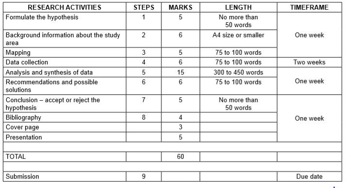
Step 1: Formulating a hypothesis/problem statement.
Guideline: geography grade 12 research tasks.
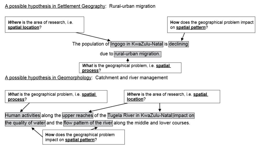
Step 1: Formulating a hypothesis/problem statement. As Geographers we seek to understand and explain the interactions amongst humans, and between humans and the environment in space and time. This is achieved by asking questions or making informed geographical decisions. This entails the development of a hypothesis or a problem statement to be tested.
- You have to choose a specific area of study where a geographical problem exists.
- During this stage, a geographical question showing a problem is asked.
- Identify the problem from a local area.
- Formulate a hypothesis or a problem statement. (Hypothesis research is used to prove that certain variables are dependent on or independent of each other. Problem statement research is only to highlight that a specific problem exists in a specific community.)
- You should then follow the steps of research to ensure that the geographical question is answered.
Geography Research Project Topics for Grade 12 South Africa
- The value of property along north-facing slopes is higher than the value of property along south-facing slopes in Meyersdal, Gauteng (choose local area).
- The cause of rural-urban migration in Ndwedwe, KwaZulu-Natal (choose local area), is the lack of service delivery in the health sector.
- Climate change will impact negatively on grape farming and related industries in the Western Cape.
- The closing down of many primary schools in Lusikisiki (Eastern Cape) (choose a local area) is due to a decline of the population in the age group 7 to 15 years.
- The poor condition of roads (specify the names of the roads) leading to/in Harrismith, Free State (choose local area), is due to the lack of proper planning by the local municipality.
- The impact of building a dam along the Jukskei River in Gauteng (choose local area) upstream of Alexandra will reduce flooding and the subsequent loss of life in Alexandra.
- The e-toll system will impact negatively on the economic position of people using private transport in Gauteng.
- The e-toll system will impact positively on traffic flow to the major urban centres in Gauteng.
- Informal settlements in the Vhembe district of Limpopo have low levels of development due to the lack of provision of basic needs (choose ONE informal settlement in your local area.)
- Overcrowding of informal settlements is due to the lack of proper planning by the local government (choose local area).
Step 2: Background information about an area of study
- You must explain where in South Africa the study area is located. (This can be indicated on the map.)
- Describe the study area in terms of its exact position (degrees, minutes and seconds).
- Provide relevant information about the area, for example population of the area or climate of the area.
Step 3: Mapping
- You must provide a map of the area in question.
- During this stage you must create a buffer zone around the area where the geographical problem exists.
- The map should have a clear legend/key and must be drawn to scale. The scale must be indicated on the map.
- If the map used covers a wider area, buffer zones around the area of study should be created.
- The map used should be the most recent map of the study area
Step 4: Methods of data collection
(a) PRIMARY DATA SOURCES
- The use of questionnaires
- Observations
- Field trips
(b) SECONDARY DATA SOURCES
- Newspaper articles
- Government department statistics
Step 5: Analysis and synthesis of data
• Learners must use collected data now to formulate a discussion around the existing geographical problem. • At this stage learners should represent some of the information graphically where necessary, for example graphs and sketches. • Learners must analyse graphic information during this stage.
Step 6: Recommendations and possible solutions
• Learners should now make recommendations to solve the geographical problem in question. • Learners should present their original and realistic opinions as far as they possibly can.
Step 7: Conclusion – accept or reject the hypothesis
- Learners should now take a decision to either ACCEPT or REJECT the hypothesis.
- Learners must give reasons for either ACCEPTING or REJECTING the hypothesis
Step 8: Bibliography
- Learners must include a comprehensive bibliography.
- Learners must list websites in full.
- Learners must include annexures of questionnaires and interviews conducted
More Geography Grade 12 Resources
- Geography 2020 Past Papers
- Geography 2019 Past Papers
- Grade 12 Geography Exam Papers and Memos for 2019 September and November
- Geography Grade 12 Research Tasks (Topics) and Memos
Looking for something specific?
Related posts.

Geography Grade 12 June 2019 Past exam papers gathered for student use

The Path of the Tropical Cyclone Eloise: Satellite Image Map

Tropical Cyclone Nivar – Geography Grade 12 Research Task

Tropical Cyclone Freddy – Geography Grade 12 Research Task

Tropical Cyclone Hagibis – Geography Grade 12 Research Task

Geography Grade 12 Term 2 2024 Research Tasks
Previous Story
Dance Studies Grade 11 June 2023 exam question papers with the memorandums pdf download
How does the bill of rights affect you as a young person in south africa.
Grade 12 Geography
Geography grade 12 research tasks (topics) and memos (sba).
Geography Grade 12 Research Tasks (Topics) and Memos for: term 1, Term 2, Term 3 and Term 4
Assessment is a continuous planned process of identifying, gathering and interpreting information about the performance of learners, using various forms of assessment. It involves four steps: generating and collecting evidence of achievement; evaluating this evidence; recording the findings and using this information to understand and assist with the learners’ development to improve the process of learning and teaching. Assessment should be both informal (assessment for learning) and formal (assessment of learning). In both cases regular feedback should be provided to learners to enhance the learning experience.
School-based assessment (SBA) is a purposive collection of learners’ work that tells the story of learners’ efforts, progress or achievement in given areas. The quality of SBA tasks is integral to learners’ preparation for the final examinations.
This booklet serves as a resource of four exemplar SBA tasks to schools and subject teachers of Geography. SBA marks are formally recorded by the teacher for progression and certification purposes. The SBA component is compulsory for all learners. Learners who cannot comply with the requirements specified according to the policy may not be eligible to enter for the subject in the final examination.
The formal assessment tasks provide the teacher with a systematic way of evaluating how well learners are progressing. This publication includes tests, a project and a case study. Formal assessment tasks form part of a year-long formal programme of assessment. These tasks should not be taken lightly and learners should be encouraged to submit their best possible efforts for final assessment.
The teachers are expected to ensure that assessment tasks are relevant to and suitable for the learners being taught. Teachers should adapt the tasks to suit learners’ level of understanding and should be context-bound; however, they should also take cognisance of the requirements as set out in the Curriculum and Assessment Policy Statement (CAPS) document.
- 1 What Skills are Assessed for Research Tasks in Grade 12
- 2.0.1 Guideline: Geography Grade 12 Research Tasks
- 2.1 Geography Research Project Topics for Grade 12 South Africa
- 3 Step 2: Background information about an area of study
- 4 Step 3: Mapping
- 5 Step 4: Methods of data collection
- 6 Step 5: Analysis and synthesis of data
- 7 Step 6: Recommendations and possible solutions
- 8 Step 7: Conclusion – accept or reject the hypothesis
- 9 Step 8: Bibliography
- 10 More Geography Grade 12 Resources
- 11 Mid Latitude Cyclones Notes Grade 12
- 12 Geography Grade 12 2019 Exam Papers and Memos
- 13 Geography Grade 12 2020 Past Papers and Memos
- 14 Geography Grade 12 Research Tasks (Topics) and Memos (SBA)
- 15 Grade 12 Geography Exam Papers and Memos for 2019 September and November
- 16 Geography Mind the Gap study guide: Grade 12 Download
What Skills are Assessed for Research Tasks in Grade 12
The following skills are assessed. Some/All of these skills may be tested in any external examination:
- Gathering data
- Interpreting data
- Analysing data
- Comparing different sets of data
- Representing data in written, graphic or mapped format
- Problem-solving
- Drawing conclusions
- Hypothesis statements
Research framework for assessment (Guideline on administration of research task)
Step 1: Formulating a hypothesis/problem statement.
Guideline: geography grade 12 research tasks.
Step 1: Formulating a hypothesis/problem statement. As Geographers we seek to understand and explain the interactions amongst humans, and between humans and the environment in space and time. This is achieved by asking questions or making informed geographical decisions. This entails the development of a hypothesis or a problem statement to be tested.
- You have to choose a specific area of study where a geographical problem exists.
- During this stage, a geographical question showing a problem is asked.
- Identify the problem from a local area.
- Formulate a hypothesis or a problem statement. (Hypothesis research is used to prove that certain variables are dependent on or independent of each other. Problem statement research is only to highlight that a specific problem exists in a specific community.)
- You should then follow the steps of research to ensure that the geographical question is answered.
Geography Research Project Topics for Grade 12 South Africa
- The value of property along north-facing slopes is higher than the value of property along south-facing slopes in Meyersdal, Gauteng (choose local area).
- The cause of rural-urban migration in Ndwedwe, KwaZulu-Natal (choose local area), is the lack of service delivery in the health sector.
- Climate change will impact negatively on grape farming and related industries in the Western Cape.
- The closing down of many primary schools in Lusikisiki (Eastern Cape) (choose a local area) is due to a decline of the population in the age group 7 to 15 years.
- The poor condition of roads (specify the names of the roads) leading to/in Harrismith, Free State (choose local area), is due to the lack of proper planning by the local municipality.
- The impact of building a dam along the Jukskei River in Gauteng (choose local area) upstream of Alexandra will reduce flooding and the subsequent loss of life in Alexandra.
- The e-toll system will impact negatively on the economic position of people using private transport in Gauteng.
- The e-toll system will impact positively on traffic flow to the major urban centres in Gauteng.
- Informal settlements in the Vhembe district of Limpopo have low levels of development due to the lack of provision of basic needs (choose ONE informal settlement in your local area.)
- Overcrowding of informal settlements is due to the lack of proper planning by the local government (choose local area).
Step 2: Background information about an area of study
- You must explain where in South Africa the study area is located. (This can be indicated on the map.)
- Describe the study area in terms of its exact position (degrees, minutes and seconds).
- Provide relevant information about the area, for example population of the area or climate of the area.
Step 3: Mapping
- You must provide a map of the area in question.
- During this stage you must create a buffer zone around the area where the geographical problem exists.
- The map should have a clear legend/key and must be drawn to scale. The scale must be indicated on the map.
- If the map used covers a wider area, buffer zones around the area of study should be created.
- The map used should be the most recent map of the study area
Step 4: Methods of data collection
(a) PRIMARY DATA SOURCES
- The use of questionnaires
- Observations
- Field trips
(b) SECONDARY DATA SOURCES
- Newspaper articles
- Government department statistics
Step 5: Analysis and synthesis of data
• Learners must use collected data now to formulate a discussion around the existing geographical problem. • At this stage learners should represent some of the information graphically where necessary, for example graphs and sketches. • Learners must analyse graphic information during this stage.
Step 6: Recommendations and possible solutions
• Learners should now make recommendations to solve the geographical problem in question. • Learners should present their original and realistic opinions as far as they possibly can.
Step 7: Conclusion – accept or reject the hypothesis
- Learners should now take a decision to either ACCEPT or REJECT the hypothesis.
- Learners must give reasons for either ACCEPTING or REJECTING the hypothesis
Step 8: Bibliography
- Learners must include a comprehensive bibliography.
- Learners must list websites in full.
- Learners must include annexures of questionnaires and interviews conducted
More Geography Grade 12 Resources
- Geography 2020 Past Papers
- Geography 2019 Past Papers
Grade 12 Geography Exam Papers and Memos for 2019 September and November
- Geography Grade 12 Research Tasks (Topics) and Memos

Mid Latitude Cyclones Notes Grade 12

- March 24, 2021

Geography Grade 12 2019 Exam Papers and Memos
- February 28, 2021

Geography Grade 12 2020 Past Papers and Memos

- February 22, 2021

- September 29, 2020
Geography Mind the Gap study guide: Grade 12 Download
- August 17, 2020
Read All Posts
Geography Grade 12 2020 Past Papers and Memos for study revision
You may like
Your email address will not be published. Required fields are marked *
Save my name, email, and website in this browser for the next time I comment.
Download Geography Grade 12 September 2020 Past Papers and Memos
Geography Grade 12 September 2020 Past Papers and Memos paper 1 and paper 2 pdf download
List of Geography Grade 12 September 2020 Past Papers and Memos
Geography grade 10, main reasons why is south africa regarded as a developing country.
Reasons why is South Africa regarded as a developing country: South Africa has a great economic infrastructure and natural resources that characterize its economy. In South Africa, there is outstanding progress in the field of industry and manufacturing. South Africa, however, is still characterised as a developing country and not a developed country.
- 0.1 6 Characteristics of a Developed Country
- 0.2 5 Reasons why is South Africa regarded as a developing country
6 Characteristics of a Developed Country
1. Has a high income per capita. Developed countries have high per capita incomes each year. By having a high income per capita, the country’s economic value will be boosted. Therefore, the amount of poverty can be overcome.
2. Security Is Guaranteed. The level of security of developed countries is more secure compared to developing countries. This is also a side effect of sophisticated technology in developed countries. With the sophisticated technology, security facilities and weapons technology also develop for the better.
3. Guaranteed Health. In addition to ensuring security, health in a developed country is also guaranteed. This is characterized by a variety of adequate health facilities, such as hospitals and medical staff who are trained and reliable.
4. Low unemployment rate. In developed countries, the unemployment rate is relatively small because every citizen can get a job and work.
5. Mastering Science and Technology. The inhabitants of developed countries tend to have mastered science and technology from which new useful products such as the industrial pendant lights were introduced to the market. Therefore, in their daily lives, they have also used sophisticated technology and modern tools to facilitate their daily lives.
6. The level of exports is higher than imports. The level of exports in developed countries is higher than the level of imports because of the superior human resources and technology possessed.
5 Reasons why is South Africa regarded as a developing country
1. South Africa has a low Income per year. Annual income in developing countries is not as high as in developed countries due to the high unemployment rate.
2. In South Africa, security is not guaranteed. Unlike in developed countries, security in developing countries is still very minimal and inappropriate. Therefore, crime rates in developed countries such as South Africa tend to be relatively high.
3. South Africa has a fast-growing population . According to the World Population Review , South Africa’s population will continue to grow until 2082, reaching just over 80 million people before plateauing and slightly declining the rest of the century. South Africa’s population growth rate is currently 1.28% per year. Developing countries have a very large average population compared to developed countries because of uncontrolled population development. This is also a result of the lack of education and health facilities.
4. The unemployment rate in South Africa is high. South Africa has an unemployment rate of 34.4% in the second quarter of 2021. In developing countries, the unemployment rate is still relatively high because the available job vacancies are not evenly distributed. In addition, the level of uneven education is also one of the factors causing the large unemployment rate.
5. Imports are higher than exports. Due to the low management of natural resources and human resources in developing countries, developing countries more often buy goods from abroad. To eliminate the barriers of being a developed country, South Africa must reduce imports and must refine and develop its agricultural sector.
Characteristics of Developed and Developing Countries
Why_is_South_Africa_Still_a_Developing_Country
Geography Grade 12 November 2020 Question Papers and for study revision
Geography Grade 12 November 2020 Question Papers and Memos pdf download
List of Geography Grade 12 November 2020 Question Papers and Memos
Describe how Ubuntu fight social challenges
Physical Science Grade 12 Notes pdf for study revision
Diane tsa Setswana le ditlhaloso: downloadable pdf
Grade 8 ems Exam Questions and Answers
91 Unique English Speech Topics for Grade 11 | Class 11: Education Resource
Popular Sesotho Idioms: Maele a Sesotho le Ditlhaloso – English Translations
My Name Poem by Magoleng wa Selepe: Questions and Answers
Life Sciences Practical Tasks Grade 11 SBA for all Terms: Education Resource
RURAL SETTLEMENT AND URBAN SETTLEMENT GRADE 12 NOTES - GEOGRAPHY STUDY GUIDES
- Study of settlements
- Rural settlements
- Urban settlements
3.1 Study of settlements
In this chapter we learn that settlements are classified according to function, or size and complexity. 3.1.1 Function
- Rural settlements are mainly unifunctional (they have one main function) with only primary economic activities occurring, e.g. farming or forestry.
- Urban settlements are multifunctional (they have many functions), i.e. they have both secondary activities (factories/manufacturing) and tertiary activities (services).
3.1.2 Size and complexity
- Settlements are classified from the smallest to the largest.
- A farmstead, hamlet and village are rural settlements.
- A town, city, metropolis, conurbation and megalopolis are urban settlements.
Study Figure 3.1.2 below to understand the differences in size and complexity of rural and urban settlements.
Figure 3.1.2: Size and complexity of settlements It is important to be able to classify settlements according to their function, size and complexity, and pattern. Activity 3.1 Complete the table to illustrate your understanding of the classification of settlements as either rural or urban.
Answers to activity 3.1
3.2 Rural settlements
Rural settlements are the smallest settlements which are unifunctional. They are farmsteads, hamlets or villages, where primary activities (farming, fishing, forestry or mining) take place. Figure 3.2.A illustrates a rural settlement.
Land use in rural settlements The largest land use in South Africa is agriculture. Approximately 12, 1% of the land is used for both commercial and subsistence cultivation of crops. Although rural communities focus on primary economic activities (farming and forestry), there are a number of different ways in which the land in these settlements can be used. Subsistence farming involves using the land to grow crops and breed animals that are a source of food for the family living on the farm. The aim is not to sell the goods, but to consume them. Commercial farming is practised where the land is used to grow crops or breed animals that are then sold as food sources to other markets. The main aim of this rural land use is to generate income for the farmers. Commercial farming can be either intensive or extensive. Commercial farming can be divided into:
- Stock farming: Animals, for example, cows, chicken, sheep, pigs.
- Crop farming: Cultivation of land, for example, maize, wheat, fruit, vegetables.
- Mixed farming: A combination of stock and crop farming.
You need to know how to identify stock and crop farming on a map. Rural settlement patterns A rural settlement pattern refers to whether the farmsteads are grouped together or not. There are two rural settlement patterns:
- Nucleated pattern: Farmsteads are arranged close to one another. Figure 3.2.B (below left) shows a nucleated pattern. These buildings are rural, so they cannot be classified as being larger than a hamlet or village.
- Dispersed pattern: Farmsteads are arranged far apart from one another. Figure 3.2.C (below right) shows a dispersed pattern. This can only be an isolated farmstead – this is one farm house, stables or sheds or kraals, and surrounding fields.
Table 3.1: Advantages and disadvantages of living in a dispersed or nucleated rural settlement When you learn these advantages and disadvantages remember that:
- If it is an advantage for nucleated it will be a disadvantage for dispersed.
- If it is a disadvantage for dispersed it will be an advantage for nucleated.
3.2.1 Reasons for the location of rural settlements Where a settlement occurs is referred to as its location. We will discuss the location of settlements under the headings site and situation.
- The site of a rural settlement refers to the exact piece of ground the settlement is found on.
- The situation of a settlement refers to the settlement in relation to its surrounding environment.
- Availability of water
- Arable (fertile) land
- Pastoral (grazing) land
- Building materials
- Fuel such as wood from a forest
Situation of a settlement When choosing a situation for rural settlements the following factors are considered:
- Above the flood line away from a river
- On the north-facing slope for warmer temperatures
- In the thermal belt for warmer night time temperatures
- Next to a road for accessibility
[16] Practise applying what you have learnt about the site and situation of rural settlements by completing Activity 3.2. Answers to activity 3.2
[16] 3.2.2 Rural-urban migration As countries develop and urban areas expand, more and more people move from the rural areas to cities and towns. This movement of people from a rural area to an urban area is called rural-urban migration. In this section we look at the factors that cause people to leave the rural areas (push factors) and move to the urban areas (pull factors). We will also look at what governments do to keep people in the rural areas.
Push and pull factors causing people to leave the rural areas Table 3.2 below summarises the factors that make people want to leave the rural areas and move to cities. Make sure you understand the difference between push and pull factors.
Table 3.2: Push and pull factors
Strategies for getting people to stay in rural areas Rural to urban migration causes many problems in rural and urban areas. Because of this, the government has various solutions or strategies (plans) to keep people in rural areas and to attract people back to rural areas. Agenda 21 is a broad strategy to develop rural areas. Some of the basic ideas are included in the list below:
- Before you can implement a solution, it is important to speak to the local people and get their ideas on how to improve the area.
- Solutions should look to use the skills and talents of the local people.
- Basic needs (food, shelter, clothing and clean running water) must be satisfied before other development can happen.
- Improve services (like electricity and roads) and facilities (like hospitals and schools) to encourage people to stay in the area.
- When providing for these basic needs, such as building roads or clinics, use local labour and train people so they can use their new skill or trade to earn a living in the area.
- Improve food security by educating farmers in the use of better farming methods, tools and seeds.
- Attract secondary activities, like factories, to rural areas. Encourage these industries to use local raw materials and skills to ensure rural people are employed.
Rural depopulation does not only affect rural areas but also small towns. Many people are leaving small towns to move to the big cities. Below are some basic ideas to consider when improving small towns:
- Improve roads to and from the small town.
- Upgrade facilities in the small town.
- Build old age homes and offer services specifically for older people. This would attract older people to retire to the small town.
- Develop a holiday resort, or attract people for weekend getaways to the small town.
3.3 Urban settlements
- Availability of water: This is no longer as relevant, since water can be piped over long distances.
- Soil: People prefer to build on soil which allows water to drain through it. It is difficult to build on clay because water collects on top of this type of soil.
- Rock structure: Sites which are far from sinkholes, fault lines and volcanoes are better to build on.
- Relief: Sites with gentle gradients are preferred, as building costs are cheaper.
- Transport and trade: Development often occurs at a river crossing.
- Human factors: Sites with historical, cultural or social value attract people to live in the area.
In an exam you may be asked to identify factors that affected the choice of a particular settlement in a diagram. In this type of question, if a key is given look at it carefully to help you answer the question. Learn the information (left) to help you answer this question.
3.3.2 Types of urban settlements Urban areas are classified according to their function (the main reason why they are there). There are three main types of urban areas:
- Central places
- Trade and transport towns or cities
- Specialised town or cities
Table 3.3 summarises the three types of urban areas.
Table 3.3: The three types of urban areas
Make up your own mnemonics to remember the facts about these three types of urban areas (see page xi in the introduction to learn more about mnemonics). Central places Central places are small towns that supply urban services to the surrounding rural area. They have shops that sell basic goods or provide basic services to people who live and work on the farms in the area. Goods or services may be classified as low or high order. Study Table 3.4 below to learn the differences between low and high order goods or services.
Table 3.4: Low and high order goods or services
- Threshold population: The number of people a function must serve in order to be profitable, or the number of people needed to support a function or town. Threshold population refers to how many customers a shop or service must have in order to be profitable.
- Range: The distance a person will travel to obtain a particular good or service. Range refers to how far someone will travel to buy a particular product or access a particular service.
- Sphere of influence or service area: The area served by a business selling a particular good or service. This is the area where people live who buy goods from a particular shop or use a particular service.
Make sure you know these three definitions which relate to central places. They are easy marks!
Activity 3.3
- Threshold population (1 × 2 = 2)
- Range (1 × 2 = 2)
- Write definitions to show your understanding of the terms in a), b) and c). (3 × 2 = 6) [12]
Related Items
- Valley Climate Grade 12 Geography Notes
- GEOGRAPHY RESEARCH TASK GRADE 12 TERM ONE 2022
- Mid-latitude and Tropical Cyclones Grade 12 Notes
- MAPWORK QUESTIONS AND ANSWERS GRADE 12
- ECONOMIC GEOGRAPHY OF SOUTH AFRICA QUESTIONS AND ANSWERS GRADE 12
- RURAL SETTLEMENT AND URBAN SETTLEMENT QUESTIONS AND ANSWERS GRADE 12
- GEOMORPHOLOGY QUESTIONS AND ANSWERS GRADE 12
- CLIMATE AND WEATHER QUESTIONS AND ANSWERS GRADE 12
- FULL COLOR MAPS GRADE 12 NOTES - GEOGRAPHY STUDY GUIDES
- MAPWORK GRADE 12 NOTES - GEOGRAPHY STUDY GUIDES
Apply what you have learnt about central places by completing activity 3.3.
Trade and transport towns or cities These are towns or cities which develop at a point where transport routes meet. Easy access to trade and transport in the area is the reason why people settle there. There are three types of trade and transport cities:
- Break-of-bulk towns or cities: They develop at a point where the type of transport changes. This is most often at a harbour where the transport changes from sea to land.
- Junction towns or cities: They develop at an intersection of two major transport routes, for example a railway junction.
- Gap towns or cities: They develop at a point of access through or over a physical barrier, for example at a mountain pass.
Specialised towns or cities These are towns or cities which have developed because of one main or dominant function occurring in the area. If the function were to stop then the city would be at risk of becoming a ghost town (a deserted town). Examples of specialised towns or cities are:
- Mining towns or cities, e.g. Welkom
- Education towns or cities, e.g. Grahamstown
- Industrial towns or cities, e.g. Secunda, Sasolburg
- Resort towns or cities, e.g. Margate
- Dormitory or commuter towns or cities, e.g. Soweto
In an exam, you may be asked to identify the type of trade and transport city in a diagram. If a key is given, look at it carefully to help you answer the question. Learn the information above to help you answer this question. 3.3.3 Structure of an urban area The study of an urban area involves focusing on the following three aspects:
- Urban profile
- Urban street patterns
- Urban land use zones
- Looking at the city from the centre towards the outskirts The height of the buildings decreases the further away you go from the centre of the city. The density (how many buildings there are in an area) also decreases the further you go from the city centre. The reason for the decrease in density and height is because land value decreases as you move away from the centre of the city.
- Looking at a city from the outskirts towards the centre The height of the buildings increases the closer you get to the city centre. The density of the buildings also increases the closer you get to the city centre.
- Thinking about land value Land value in the centre of the city is very high because it is in high demand (lots of people value it and want to live or work there). The land value decreases the further you go from the city centre. The density and height in the centre of the city is highest because of the high land value. People must make maximum use of the land. This is why there are many high-rise buildings in the city centre. Due to the high land value in the city centre, certain functions will move to the outskirts of the city, such as factories, businesses and residential (houses). Factories and business are often located in specific areas known as industrial or office parks. Houses are located in residential suburbs.
- On the urban profile shown in Figure 3.3.3B on page 56 draw a line graph to show how land value changes as you move towards the CBD. (1 × 2 = 2)
- How does building density change as you move towards the centre of the city? (1 × 2 = 2)
- Explain your answer in question 2. (2 × 2 = 4)
- Why would an office park move away from the Central Business District? (2 × 2 = 4) [12]
Apply your understanding of urban profiles by completing Activity 3.4.
Urban street patterns The structure of an urban area can be studied from above by looking at the patterns formed by the streets of the urban area. The layout or arrangement of the roads is called the street pattern. In this section we focus on four street patterns:
- Planned irregular
- Unplanned irregular
Study Figures 3.3.3A to D to G (below and on page 58) to understand the four street patterns.
In Paper 1 or Paper 2 you may be asked to identify the street pattern and state the advantages and disadvantages of the street pattern. You may also be asked to give the age of a settlement based on the street pattern in the settlement.
Urban land use zones The structure of an urban area can be studied by looking at the different land use zones in a city. A land use zone is an area which has features that define its function. For example, a residential area is made up of houses or flats, recreational areas, schools and shops. These features tell us that people live in the area. Another example is an industrial area, which is made up of many large buildings (factories), major transport routes and few open or green areas. Urban street patterns will be tested in activity 3.5 in the mapwork interpretation of settlement based on the Nelspruit map. The photographs and some orthophotos in Figures 3.3.3H (i)–(xiv) below show different land use zones and their features. An orthophoto is an aerial photograph that has been geometrically corrected so that the scale is uniform and there is no visual distortion. Remember, aerial means ‘seen from above’.
See if you can find examples of these land use zones in the area where you live. Land use models Land use models are simplified diagrams which are used to represent the pattern of land use functions within a city or a town. It should be remembered that these are a simplification of reality and it is unlikely that any model will fit every town or a city well. The urban models listed below are a few examples of the currently used urban models in the world. They are:
- Multiple nuclei model
- The modern American-Western city model
- Third world city model
- South African city model.
In Paper 1 and Paper 2 you may be asked to identify the land use zones seen in diagrams, cartoons, photographs and on a topographic map or on an orthophoto. You may also be asked to describe the characteristics of the land use zone. Learn the above information to help you answer the question. Activity 3.5 This activity is a mapwork interpretation of a settlement. Refer to the topographic map 2530BD Nelspruit and the orthophoto map extract at the back of this study guide and answer the following questions.
- Nelspruit/Mbombela is the capital of which South African province? (1 × 2 = 2)
- What factors influenced the site of Nelspruit/ Mbombela? (4 × 2 = 8)
- Discuss the situation of Nelspruit/Mbombela. (3 × 2 = 6)
- Identify the settlement pattern in block C2. Give a reason to support your answer. (2 × 2 = 4)
- What is the shape of the settlement in block B3? Why do you think it has taken this shape? (2 × 2 = 4)
- Classify the type of farming in block C3 as fully as possible, explaining your answer. (3 × 2 = 6)
- What is different about the farm Friedenheim in block C5? (1 × 2 = 2)
- How could this farm help to prevent rural–urban migration? (1 × 2 = 2)
- What type of city would Nelspruit/Mbombela be classified as? Explain your answer. (2 × 2 = 4)
- Give the block reference of the land use zone known as the CBD. (1 × 2 = 2)
- Draw a simple cross section sketch to illustrate the urban profile of the land use zone in question a). (2 × 2 = 4)
- What type of street pattern is found in this zone? Give two advantages and two disadvantages for this street pattern. (5 × 2 = 10)
- West Acres is an example of an upper income residential area. Give two reasons from the map to support this statement. (2 × 2 = 4) Study the orthophoto at the back of the study guide.
- What land use is found at A, B, C and D? (4 × 2 = 8)
- The residents of West Acres do not like travelling to the centre of Nelspruit/Mbombela to do their shopping as it has become so congested. Where would you suggest that they build a new shopping mall? Explain why you have chosen this site to build on. (3 × 2 = 6) [70]
- Away from the CBD
- It has large blocks of land between the roads.
- Street pattern plan is irregular
- It is on the warmer, north-facing slope so land will be more expensive.
- Away from pollution and noise (any 2) (4) Questions based on the orthophoto:
- = Transport (railway station)/Industrial
- = Commercial/Business – CBD
- = Residential
- = Recreation/Showground (8)
- The land is not being used for other purposes.
- It is near a road so people living nearby can get there easily.
- It is close to the suburb West Acres.
- The land here is quite flat (as indicated by the contours that are far apart). (any 3 reasons) (6) [70]
Study Tables 3.5 to 3.7 to learn about the causes, effects and solutions to these three urban problems. 3.3.4 Urban settlement problems As an urban area grows and more people move into the area, certain problems are created and get worse as the city gets bigger. These problems are often worse in the CBD. In this section we focus on the following three urban problems:
- Urban decay
- Centralisation
Table 3.5: Causes, effects and solutions to the urban problem of congestion
Table 3.6: Causes, effects and solutions to the urban problem of urban decay
Table 3.7: Causes, effects and solutions to the urban problem of centralisation In an exam you may be asked to state the causes or effect or solution to an urban problem. You may also be asked to describe the causes or effect or solution to an urban problem in a paragraph. 3.3.5 Economic, social and environmental injustice In geography you are often asked to describe, explain, or discuss the effect, impact, or injustice of particular phenomena. To do this, we first need to understand the meanings of these words.
- Injustice: inequity, unfairness, unjustness, wrong, grievance; means an act that inflicts undeserved hurt. Injustice applies to any act that involves unfairness to another or violation of one’s rights
- Opposite of injustice: equity, fairness, justice.
- Economic injustice: when different people have different levels of income in a society.
- Social Injustice: the distribution of advantages and disadvantages within a society.
- Environmental injustice: the unfair distribution of environmental benefits and burdens. Environmental justice is the fair treatment and meaningful involvement of all people regardless of race, colour, national origin, or income with respect to the development, implementation, and enforcement of environmental laws, regulations, and policies.
- Impact: the effect or impression of one thing on another.
- Effect: something brought about by a cause or agent; a result or outcome.
In Geography when a question refers to economic, social and environmental factors, impacts or injustices the term relates to the following:
- Economic: this term deals with the making of or losing money by business, countries, and individuals. It includes economic activities (primary, secondary, and tertiary activities). It is concerned with the human-made environment; the infrastructure and buildings.
- Social: this term relates or deals with people, demographic factors (birth rates, death rates, income, literacy levels and employment), and basic needs.
- Environmental: of, relating to, or associated with the environment.
In a test or exam the question would be as shown below. Possible answers are given.
Discuss the economic, social, and environmental injustices of the following: Or Discuss the economic, social, and environmental impacts or effects of the following:
- Flooding (Mid-latitude cyclones, tropical cyclones)
- Drought (HP cells)
- Global warming
- Zone of decay/Overpopulation or overcrowding
- Rural depopulation
- Globalisation/Increased trade
- What is a settlement? (1 × 2 = 2)
- Is the settlement shown in Figure 3.3.5A a rural or an urban settlement? (1 × 2 = 2)
- Give one reason for your answer to question b) above. (1 × 2 = 2)
- Distinguish between a low-order function and a highorder function. (2 × 2 = 4)
- From Figure 3.3.5A, identify one low-order function and one high-order function. (1 × 2 = 2)
- Explain the meaning of the term sphere of influence of a function or service. (1 × 2 = 2)
- Will the hospital or the café have a larger sphere of influence? (1 × 2 = 2)
- Explain your answer to question d) above. (2 × 2 = 4)
- The bakery is an example of a light industry. What is a light industry? (1 × 2 = 2)
- Unlike a heavy industry, the bakery can be located close to the hospital. Explain why this bakery does not have to be located outside the city. (2 × 2 = 4)
- Why is it important for the bakery to have a central location? (2 × 2 = 4)
- With reference to Figure 3.3.5A, explain why many people from the surrounding rural areas are attracted to this settlement. (2 × 2 = 4)
- Explain why it is important for the illustrated settlement to slow down the movement of people from rural areas to this settlement. (2 × 2 = 4) [38]
Apply your knowledge from the whole settlement section to complete activities 3.6 and 3.7.
Activity 3.7 Refer to Figure 3.7 and read the following extract (Cape Peninsula) before you answer the questions that follow.
Question 1 Refer to the wine farms located in the area of Constantia. Wine farm estates are examples of isolated farmsteads. 1.1 Define the term isolated farmstead. (1 × 2 = 2) 1.2 State two economic advantages of this settlement pattern. (2 × 2 = 4) 1.3 Describe two social disadvantages of this settlement pattern. (2 × 2 = 4) 1.4 Wine farms in South Africa form part of all three economic activities: primary, secondary and tertiary activities. Explain this statement in a short a paragraph (no more than 12 lines). (6 × 2 = 12) [22]
- What do the letters CBD stand for? (1 × 2 = 2)
- Identify the street pattern of the CBD of Cape Town. (1 × 2 = 2)
- Provide one advantage and one disadvantage of this street pattern. (2 × 2 = 4)
- With reference to Figure 3.7, identify one characteristic of the CBD’s profile. (1 × 2 = 2)
- Explain why the CBD has the characteristic you identified in question d). (2 × 2 = 4)
2.5 What evidence is there that the CBD of Cape Town is the most accessible land use zone? (1 × 2 = 2) [24]
Question 3 Refer to the residential areas of Sea Point and the Malay Quarters. 3.1
- Classify the two areas as low- or high-income areas respectively. (2 × 2 = 4)
- Explain your classification of Sea Point in question a) by referring to evidence from Figure 3.7. (2 × 2 = 4)
3.2 The open space around the Malay Quarter may attract migrants from the rural areas.
- What is likely to develop here as a result of this migration? (1 × 2 = 2)
- Explain the occurrence of this development. (2 × 2 = 4)
- State two reasons for these migrants leaving the rural areas. (2 × 2 = 4)
- What problems are associated with this development? (2 × 2 = 4)
- You are part of a task team set up by the government to provide suggestions on how to slow the movement of people from the rural areas, as well as attract people back to small towns. In a short paragraph (no more than 12 lines), discuss some of your suggestions. (6 × 2 = 12) [34]
Question 4 4.1 Provide the correct term for the following phrases:
- A settlement where only primary activities occur (1 × 2 = 2)
- An urban settlement which consists of a main city with surrounding dependent towns (1 × 2 = 2)
- The increase in the number of people living in an urban area (1 × 2 = 2)
- A resource from the earth which cannot be replenished. (1 × 2 = 2)
- The economic sector which involves the accessing and distribution of information. (1 × 2 = 2)
4.2 Match the columns. Simply write the number of the term in Column A next to the letter of the correct phrase from Column B.
Related items
- Mathematics Grade 12 Investigation 2023 Term 1
- TECHNICAL SCIENCES PAPER 2 GRADE 12 QUESTIONS - NSC PAST PAPERS AND MEMOS JUNE 2022
- TECHNICAL SCIENCES PAPER 1 GRADE 12 QUESTIONS - NSC PAST PAPERS AND MEMOS JUNE 2022
- MATHEMATICS LITERACY PAPER 2 GRADE 12 MEMORANDUM - NSC PAST PAPERS AND MEMOS JUNE 2022
- MATHEMATICS LITERACY PAPER 2 GRADE 12 QUESTIONS - NSC PAST PAPERS AND MEMOS JUNE 2022
You are using an outdated browser. Please upgrade your browser or activate Google Chrome Frame to improve your experience.
Geography Gr. 12 Urban Settlement Issues T2 W6
Urbanisation, Overcrowding, Traffic congestion and Urban decay Informal settlements and related issues
Do you have an educational app, video, ebook, course or eResource?
Contribute to the Western Cape Education Department's ePortal to make a difference.
Home Contact us Terms of Use Privacy Policy Western Cape Government © 2024. All rights reserved.

IMAGES
VIDEO
COMMENTS
What Skills are Assessed for Research Tasks in Grade 12. Step 1: Formulating a hypothesis/problem statement. Geography Research Project Topics for Grade 12 South Africa. Step 2: Background information about an area of study. Step 3: Mapping. Step 4: Methods of data collection. Step 5: Analysis and synthesis of data.
Siya Geography; RM 00 01 Wolfe; Informal settlements handbook compressed; ... This research task consists of 6 pages and a separate rubric and a recording sheet. RESEARCH TASK 3 GRADE 12 GEOGRAPHY TERM ONE 2023 INSTRUCTIONS AND INFORMATION TO EDUCATORS AND LEARNERS 1. Choose a topic in any section of Geography grade 12 and conduct a research ...
notes for gr 12 settlement geography grade 12 (2023) unit study of settlements p188 settlement place where people live. grouping of people, buildings, Skip to document. University; High School. Books; Discovery. ... Grade 12 (2023) settlement geography . UNIT 1: STUDY OF SETT LEMENTS p188 . Settlemen t. A place whe re people liv e.
2.0.1 Guideline: Geography Grade 12 Research Tasks. 2.1 Geography Research Project Topics for Grade 12 South Africa. 3 Step 2: Background information about an area of study. 4 Step 3: Mapping. 5 Step 4: Methods of data collection. 6 Step 5: Analysis and synthesis of data. 7 Step 6: Recommendations and possible solutions.
Related documents. Finished Rapid RISE - INFORMAL SETTLEMENTS; Almost DONE Infrustructure; 1. Term 2 Grade 12 Project - Eng 2024 101833; Research Gr12 2024-1-1
Refer to the photograph and extract below on informal settlements. INFORMAL SETTLEMENTS IN SOUTH AFRICA DBE/2023 (2) (4) (8) [60] 1.5 Government reports suggest that between 2002 and 2021, informal settlements in South Africa increased from 300 to 2 180. The poverty levels in informal settlements are evident in the tiny spaces,
RURAL SETTLEMENT AND URBAN SETTLEMENT QUESTIONS AND ANSWERS GRADE 12. Complete the table to illustrate your understanding of the classification of settlements as either rural or urban. Study the two rural settlement diagrams in Figures 3.2.1B and 3.2.1C and complete the table.
Settlements are classified from the smallest to the largest. A farmstead, hamlet and village are rural settlements. A town, city, metropolis, conurbation and megalopolis are urban settlements. Study Figure 3.1.2 below to understand the differences in size and complexity of rural and urban settlements. Rural.
2.5.2 Explain why there are so many informal settlements in urban areas. (1x2) (2) 2.5.3 Which services are the residents of Sakhile informal settlement demanding? (2x2) (4) 2.5.4 In a paragraph of approximately eight lines, suggest measures that can be implemented to improve conditions at Sakhile Informal settlement. (4x2) (8) (15) (60)
This study guide is intended to serve as a resource for teachers and learners. It provides notes, examples, problem-solving exercises with solutions and examples of practical activities. Language: English. Curriculum Alignment: CAPS aligned. Publication Date: 2022-02-09. Grade:
Research Task Grade 12 2024 - Free download as PDF File (.pdf), Text File (.txt) or view presentation slides online. This document provides guidelines for Grade 12 geography students in South Africa to complete a research task. It outlines the requirements and marking rubric for the research, which includes formulating a hypothesis, mapping the research area, collecting and analyzing data ...
Mapwork Grade 10; Geography GR 11 Paper 1; Geography Grade 11 Reserach 2024 ... Related Studylists My notes palesa galeboe. Preview text. Gr 12 Geography SETTLEMENT GEOGRAPHY 2 How site and situation affect the location of rural ... Urban fringe activities: airports, waterworks, waste dumps, sewage works, informal settlements and market gardens ...
Gr 12 Geography SETTLEMENT GEOGRAPHY URBAN SETTLEMENT ISSUES 7.1 Recent urbanisation patterns in South-Africa. Change in demographic profile of SA cities. Cities attract high numbers of youth - largest proportion of formal and informal labour market. Represent skilled workers, HOWEVER - biggest number of unskilled,
GEOGRAPHY - GRADE 12 2024 TOPIC ASSESSMENT STANDARDS PORTFOLIO ASSESSMENT TASKS ... Assignment 15 - 19 April Task 4: Mid-year Exams 13 May - 31 May Rural settlement Study of settlements Rural settlements ... Informal sector . Author: L Chain Created Date:
GRADE 12 SEPTEMBER 2023 GEOGRAPHY P1 MARKING GUIDELINE MARKS: 150 ... Heavy rainfall will cause informal settlements to become inaccessible/cut off (2) Low temperatures would cause residents to fall ill (2) Gale force winds would destroy/damage informal structures (2) [ANY TWO] (2 x 2) (4) 1.4 1.4.1 5 (1) (1 x 1) (1) ...
WORK SHEET 3 - Settlement geography QUESTION 1: Study the sketch below and answer the questions below. (Think what it shows) Source: NSC Feb/March 2012 Paper 1 1.1 Identify the term described by the following definitions: 1.1.1 The process where many people are leaving rural areas to find better lives.
A human settlement is made up of five ekistic elements, which are interactive and independent with each other. These are man, nature, shells, networks and society. Doxiadis definition of settlements. A grouping of people, activities, building structures and communication networks that function as a single integrated system on a regular daily basis.
Geography Grade 12 - Cyclone Freddy. Geography. Assignments. 100% (28) 9. Research Gr12 2024-1-1. ... ADFM Essentials of Financial Management July 2023 S1 Assignment; Geography NSC P1 Memo Sept 2021 Eng Eastern Cape; Geography P1 Sept 2020 Memo Eng; ... informal settlement dwellers on the Cape Flats.
Geography Revision Question paper and Answers 2023 Grade 12. Course. Geography. Institution. 12th Grade. This document contains Questions and Answers for Geography both Paper 1 and Paper 2. It is the best for revising and it gives you the inside of what will be happening in the final papers so use this document to prepare your self I promise it ...
Urbanisation, Overcrowding, Traffic congestion and Urban decay Informal settlements and related issues. Urbanisation, Overcrowding, Traffic congestion and Urban decay Informal settlements and related issues ... 8 Grade 9 Grade 10 Grade 11 Grade 12 ... Geography Gr. 12 Urban Settlement Issues T2 W6 . Free . By. Glenn Samaai.
The rapid rise of informal settlements and related issues in my local community ... Gr 10 Geography (English) Controlled Test 1 2023 Question Paper. Geography 100% (14) 17. 2024 Geo Grade 12 Research Task. ... Geography grade 12 assignment; PDF 1715417395837; Research Gr12 2024-1-1; Research TASK Grade 12 2024; English (ZA) ...
View EC-Geography-Grade-12-September-2023-P2-and-Memo (1).pdf from GEOGRAPHY MISC at Witwatersrand. Downloaded from Stanmorephysics.com NATIONAL SENIOR CERTIFICATE GRADE 12 SEPTEMBER 2023 GEOGRAPHY
Grade 10 Geography June Paper 1 2022 QP; Gauteng-Geography-Grade-12-June-2023-QP-and-Memo; PRE JUNE EXAM 2- 2024 - This practice material is for Mid year examination inorder to get all geography; Finaldoc GR 10 Essay T2 2024 Project Based Learning; MG Grade 10 Mapwork TASK 2024; Grade 12 Research Term 2