- Free Teaching Resources
- Universities
- Public Colleges
- Private Colleges
- N6 Question Papers and Memorandums with Study Guides
- N5 Question Papers and Memorandums with Study Guides
- N4 Question Papers and Memorandums with Study Guides
- N3 Question Papers and Memorandums with Study Guides
- N2 Question Papers and Memorandums with Study Guides
- N1 Question Papers and Memorandums with Study Guides
- Latest Updates
- Learning Content
- Grade 12 Geography Study Resources Directory


Geography Grade 12 Research Tasks (Topics) and Memos (SBA)
Geography Grade 12 Research Tasks (Topics) and Memos for: term 1, Term 2, Term 3 and Term 4
Assessment is a continuous planned process of identifying, gathering and interpreting information about the performance of learners, using various forms of assessment. It involves four steps: generating and collecting evidence of achievement; evaluating this evidence; recording the findings and using this information to understand and assist with the learners’ development to improve the process of learning and teaching. Assessment should be both informal (assessment for learning) and formal (assessment of learning). In both cases regular feedback should be provided to learners to enhance the learning experience.
School-based assessment (SBA) is a purposive collection of learners’ work that tells the story of learners’ efforts, progress or achievement in given areas. The quality of SBA tasks is integral to learners’ preparation for the final examinations.
This booklet serves as a resource of four exemplar SBA tasks to schools and subject teachers of Geography. SBA marks are formally recorded by the teacher for progression and certification purposes. The SBA component is compulsory for all learners. Learners who cannot comply with the requirements specified according to the policy may not be eligible to enter for the subject in the final examination.
The formal assessment tasks provide the teacher with a systematic way of evaluating how well learners are progressing. This publication includes tests, a project and a case study. Formal assessment tasks form part of a year-long formal programme of assessment. These tasks should not be taken lightly and learners should be encouraged to submit their best possible efforts for final assessment.
The teachers are expected to ensure that assessment tasks are relevant to and suitable for the learners being taught. Teachers should adapt the tasks to suit learners’ level of understanding and should be context-bound; however, they should also take cognisance of the requirements as set out in the Curriculum and Assessment Policy Statement (CAPS) document.
Table of Contents
What Skills are Assessed for Research Tasks in Grade 12
The following skills are assessed. Some/All of these skills may be tested in any external examination:
- Gathering data
- Interpreting data
- Analysing data
- Comparing different sets of data
- Representing data in written, graphic or mapped format
- Problem-solving
- Drawing conclusions
- Hypothesis statements
Research framework for assessment (Guideline on administration of research task)
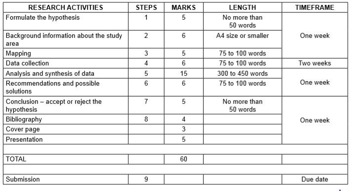
Step 1: Formulating a hypothesis/problem statement.
Guideline: geography grade 12 research tasks.
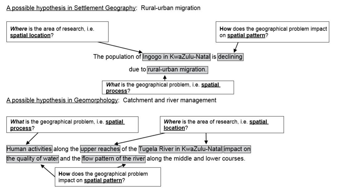
Step 1: Formulating a hypothesis/problem statement. As Geographers we seek to understand and explain the interactions amongst humans, and between humans and the environment in space and time. This is achieved by asking questions or making informed geographical decisions. This entails the development of a hypothesis or a problem statement to be tested.
- You have to choose a specific area of study where a geographical problem exists.
- During this stage, a geographical question showing a problem is asked.
- Identify the problem from a local area.
- Formulate a hypothesis or a problem statement. (Hypothesis research is used to prove that certain variables are dependent on or independent of each other. Problem statement research is only to highlight that a specific problem exists in a specific community.)
- You should then follow the steps of research to ensure that the geographical question is answered.
Geography Research Project Topics for Grade 12 South Africa
- The value of property along north-facing slopes is higher than the value of property along south-facing slopes in Meyersdal, Gauteng (choose local area).
- The cause of rural-urban migration in Ndwedwe, KwaZulu-Natal (choose local area), is the lack of service delivery in the health sector.
- Climate change will impact negatively on grape farming and related industries in the Western Cape.
- The closing down of many primary schools in Lusikisiki (Eastern Cape) (choose a local area) is due to a decline of the population in the age group 7 to 15 years.
- The poor condition of roads (specify the names of the roads) leading to/in Harrismith, Free State (choose local area), is due to the lack of proper planning by the local municipality.
- The impact of building a dam along the Jukskei River in Gauteng (choose local area) upstream of Alexandra will reduce flooding and the subsequent loss of life in Alexandra.
- The e-toll system will impact negatively on the economic position of people using private transport in Gauteng.
- The e-toll system will impact positively on traffic flow to the major urban centres in Gauteng.
- Informal settlements in the Vhembe district of Limpopo have low levels of development due to the lack of provision of basic needs (choose ONE informal settlement in your local area.)
- Overcrowding of informal settlements is due to the lack of proper planning by the local government (choose local area).
Step 2: Background information about an area of study
- You must explain where in South Africa the study area is located. (This can be indicated on the map.)
- Describe the study area in terms of its exact position (degrees, minutes and seconds).
- Provide relevant information about the area, for example population of the area or climate of the area.
Step 3: Mapping
- You must provide a map of the area in question.
- During this stage you must create a buffer zone around the area where the geographical problem exists.
- The map should have a clear legend/key and must be drawn to scale. The scale must be indicated on the map.
- If the map used covers a wider area, buffer zones around the area of study should be created.
- The map used should be the most recent map of the study area
Step 4: Methods of data collection
(a) PRIMARY DATA SOURCES
- The use of questionnaires
- Observations
- Field trips
(b) SECONDARY DATA SOURCES
- Newspaper articles
- Government department statistics
Step 5: Analysis and synthesis of data
• Learners must use collected data now to formulate a discussion around the existing geographical problem. • At this stage learners should represent some of the information graphically where necessary, for example graphs and sketches. • Learners must analyse graphic information during this stage.
Step 6: Recommendations and possible solutions
• Learners should now make recommendations to solve the geographical problem in question. • Learners should present their original and realistic opinions as far as they possibly can.
Step 7: Conclusion – accept or reject the hypothesis
- Learners should now take a decision to either ACCEPT or REJECT the hypothesis.
- Learners must give reasons for either ACCEPTING or REJECTING the hypothesis
Step 8: Bibliography
- Learners must include a comprehensive bibliography.
- Learners must list websites in full.
- Learners must include annexures of questionnaires and interviews conducted
More Geography Grade 12 Resources
- Geography 2020 Past Papers
- Geography 2019 Past Papers
- Grade 12 Geography Exam Papers and Memos for 2019 September and November
- Geography Grade 12 Research Tasks (Topics) and Memos
Did You See These?
The Path of the Tropical Cyclone Eloise: Satellite Image Map
Tropical Cyclone Nivar – Geography Grade 12 Research Task
Tropical Cyclone Freddy – Geography Grade 12 Research Task
Tropical Cyclone Hagibis – Geography Grade 12 Research Task
Geography Grade 12 Term 2 2024 Research Tasks
Geography Grade 12 June 2019 Past exam papers gathered for student use
Geography Grade 12 2023 November Comprehensive Archives Of Past Question Papers For Advanced Studies
7 Reasons Why Long-distance Aircraft Choose to Fly in the Lower Part of the Stratosphere
- Share This Post:
2 thoughts on “Geography Grade 12 Research Tasks (Topics) and Memos (SBA)”

Rapid informal settlement in rural
I want help for assessment
Add a Comment
Save my name, email, and website in this browser for the next time I comment.
Reset Password
Grade 12 Geography
Geography grade 12 research tasks (topics) and memos (sba).
Geography Grade 12 Research Tasks (Topics) and Memos for: term 1, Term 2, Term 3 and Term 4
Assessment is a continuous planned process of identifying, gathering and interpreting information about the performance of learners, using various forms of assessment. It involves four steps: generating and collecting evidence of achievement; evaluating this evidence; recording the findings and using this information to understand and assist with the learners’ development to improve the process of learning and teaching. Assessment should be both informal (assessment for learning) and formal (assessment of learning). In both cases regular feedback should be provided to learners to enhance the learning experience.
School-based assessment (SBA) is a purposive collection of learners’ work that tells the story of learners’ efforts, progress or achievement in given areas. The quality of SBA tasks is integral to learners’ preparation for the final examinations.
This booklet serves as a resource of four exemplar SBA tasks to schools and subject teachers of Geography. SBA marks are formally recorded by the teacher for progression and certification purposes. The SBA component is compulsory for all learners. Learners who cannot comply with the requirements specified according to the policy may not be eligible to enter for the subject in the final examination.
The formal assessment tasks provide the teacher with a systematic way of evaluating how well learners are progressing. This publication includes tests, a project and a case study. Formal assessment tasks form part of a year-long formal programme of assessment. These tasks should not be taken lightly and learners should be encouraged to submit their best possible efforts for final assessment.
The teachers are expected to ensure that assessment tasks are relevant to and suitable for the learners being taught. Teachers should adapt the tasks to suit learners’ level of understanding and should be context-bound; however, they should also take cognisance of the requirements as set out in the Curriculum and Assessment Policy Statement (CAPS) document.
- 1 What Skills are Assessed for Research Tasks in Grade 12
- 2.0.1 Guideline: Geography Grade 12 Research Tasks
- 2.1 Geography Research Project Topics for Grade 12 South Africa
- 3 Step 2: Background information about an area of study
- 4 Step 3: Mapping
- 5 Step 4: Methods of data collection
- 6 Step 5: Analysis and synthesis of data
- 7 Step 6: Recommendations and possible solutions
- 8 Step 7: Conclusion – accept or reject the hypothesis
- 9 Step 8: Bibliography
- 10 More Geography Grade 12 Resources
- 11 Mid Latitude Cyclones Notes Grade 12
- 12 Geography Grade 12 2019 Exam Papers and Memos
- 13 Geography Grade 12 2020 Past Papers and Memos
- 14 Geography Grade 12 Research Tasks (Topics) and Memos (SBA)
- 15 Grade 12 Geography Exam Papers and Memos for 2019 September and November
- 16 Geography Mind the Gap study guide: Grade 12 Download
What Skills are Assessed for Research Tasks in Grade 12
The following skills are assessed. Some/All of these skills may be tested in any external examination:
- Gathering data
- Interpreting data
- Analysing data
- Comparing different sets of data
- Representing data in written, graphic or mapped format
- Problem-solving
- Drawing conclusions
- Hypothesis statements
Research framework for assessment (Guideline on administration of research task)
Step 1: Formulating a hypothesis/problem statement.
Guideline: geography grade 12 research tasks.
Step 1: Formulating a hypothesis/problem statement. As Geographers we seek to understand and explain the interactions amongst humans, and between humans and the environment in space and time. This is achieved by asking questions or making informed geographical decisions. This entails the development of a hypothesis or a problem statement to be tested.
- You have to choose a specific area of study where a geographical problem exists.
- During this stage, a geographical question showing a problem is asked.
- Identify the problem from a local area.
- Formulate a hypothesis or a problem statement. (Hypothesis research is used to prove that certain variables are dependent on or independent of each other. Problem statement research is only to highlight that a specific problem exists in a specific community.)
- You should then follow the steps of research to ensure that the geographical question is answered.
Geography Research Project Topics for Grade 12 South Africa
- The value of property along north-facing slopes is higher than the value of property along south-facing slopes in Meyersdal, Gauteng (choose local area).
- The cause of rural-urban migration in Ndwedwe, KwaZulu-Natal (choose local area), is the lack of service delivery in the health sector.
- Climate change will impact negatively on grape farming and related industries in the Western Cape.
- The closing down of many primary schools in Lusikisiki (Eastern Cape) (choose a local area) is due to a decline of the population in the age group 7 to 15 years.
- The poor condition of roads (specify the names of the roads) leading to/in Harrismith, Free State (choose local area), is due to the lack of proper planning by the local municipality.
- The impact of building a dam along the Jukskei River in Gauteng (choose local area) upstream of Alexandra will reduce flooding and the subsequent loss of life in Alexandra.
- The e-toll system will impact negatively on the economic position of people using private transport in Gauteng.
- The e-toll system will impact positively on traffic flow to the major urban centres in Gauteng.
- Informal settlements in the Vhembe district of Limpopo have low levels of development due to the lack of provision of basic needs (choose ONE informal settlement in your local area.)
- Overcrowding of informal settlements is due to the lack of proper planning by the local government (choose local area).
Step 2: Background information about an area of study
- You must explain where in South Africa the study area is located. (This can be indicated on the map.)
- Describe the study area in terms of its exact position (degrees, minutes and seconds).
- Provide relevant information about the area, for example population of the area or climate of the area.
Step 3: Mapping
- You must provide a map of the area in question.
- During this stage you must create a buffer zone around the area where the geographical problem exists.
- The map should have a clear legend/key and must be drawn to scale. The scale must be indicated on the map.
- If the map used covers a wider area, buffer zones around the area of study should be created.
- The map used should be the most recent map of the study area
Step 4: Methods of data collection
(a) PRIMARY DATA SOURCES
- The use of questionnaires
- Observations
- Field trips
(b) SECONDARY DATA SOURCES
- Newspaper articles
- Government department statistics
Step 5: Analysis and synthesis of data
• Learners must use collected data now to formulate a discussion around the existing geographical problem. • At this stage learners should represent some of the information graphically where necessary, for example graphs and sketches. • Learners must analyse graphic information during this stage.
Step 6: Recommendations and possible solutions
• Learners should now make recommendations to solve the geographical problem in question. • Learners should present their original and realistic opinions as far as they possibly can.
Step 7: Conclusion – accept or reject the hypothesis
- Learners should now take a decision to either ACCEPT or REJECT the hypothesis.
- Learners must give reasons for either ACCEPTING or REJECTING the hypothesis
Step 8: Bibliography
- Learners must include a comprehensive bibliography.
- Learners must list websites in full.
- Learners must include annexures of questionnaires and interviews conducted
More Geography Grade 12 Resources
- Geography 2020 Past Papers
- Geography 2019 Past Papers
Grade 12 Geography Exam Papers and Memos for 2019 September and November
- Geography Grade 12 Research Tasks (Topics) and Memos

Mid Latitude Cyclones Notes Grade 12

- March 24, 2021

Geography Grade 12 2019 Exam Papers and Memos
- February 28, 2021

Geography Grade 12 2020 Past Papers and Memos

- February 22, 2021

- September 29, 2020
Geography Mind the Gap study guide: Grade 12 Download
- August 17, 2020
Read All Posts
Geography Grade 12 2020 Past Papers and Memos for study revision
You may like
Your email address will not be published. Required fields are marked *
Save my name, email, and website in this browser for the next time I comment.
Download Geography Grade 12 September 2020 Past Papers and Memos
Geography Grade 12 September 2020 Past Papers and Memos paper 1 and paper 2 pdf download
List of Geography Grade 12 September 2020 Past Papers and Memos
Geography grade 10, main reasons why is south africa regarded as a developing country.
Reasons why is South Africa regarded as a developing country: South Africa has a great economic infrastructure and natural resources that characterize its economy. In South Africa, there is outstanding progress in the field of industry and manufacturing. South Africa, however, is still characterised as a developing country and not a developed country.
- 0.1 6 Characteristics of a Developed Country
- 0.2 5 Reasons why is South Africa regarded as a developing country
6 Characteristics of a Developed Country
1. Has a high income per capita. Developed countries have high per capita incomes each year. By having a high income per capita, the country’s economic value will be boosted. Therefore, the amount of poverty can be overcome.
2. Security Is Guaranteed. The level of security of developed countries is more secure compared to developing countries. This is also a side effect of sophisticated technology in developed countries. With the sophisticated technology, security facilities and weapons technology also develop for the better.
3. Guaranteed Health. In addition to ensuring security, health in a developed country is also guaranteed. This is characterized by a variety of adequate health facilities, such as hospitals and medical staff who are trained and reliable.
4. Low unemployment rate. In developed countries, the unemployment rate is relatively small because every citizen can get a job and work.
5. Mastering Science and Technology. The inhabitants of developed countries tend to have mastered science and technology from which new useful products such as the industrial pendant lights were introduced to the market. Therefore, in their daily lives, they have also used sophisticated technology and modern tools to facilitate their daily lives.
6. The level of exports is higher than imports. The level of exports in developed countries is higher than the level of imports because of the superior human resources and technology possessed.
5 Reasons why is South Africa regarded as a developing country
1. South Africa has a low Income per year. Annual income in developing countries is not as high as in developed countries due to the high unemployment rate.
2. In South Africa, security is not guaranteed. Unlike in developed countries, security in developing countries is still very minimal and inappropriate. Therefore, crime rates in developed countries such as South Africa tend to be relatively high.
3. South Africa has a fast-growing population . According to the World Population Review , South Africa’s population will continue to grow until 2082, reaching just over 80 million people before plateauing and slightly declining the rest of the century. South Africa’s population growth rate is currently 1.28% per year. Developing countries have a very large average population compared to developed countries because of uncontrolled population development. This is also a result of the lack of education and health facilities.
4. The unemployment rate in South Africa is high. South Africa has an unemployment rate of 34.4% in the second quarter of 2021. In developing countries, the unemployment rate is still relatively high because the available job vacancies are not evenly distributed. In addition, the level of uneven education is also one of the factors causing the large unemployment rate.
5. Imports are higher than exports. Due to the low management of natural resources and human resources in developing countries, developing countries more often buy goods from abroad. To eliminate the barriers of being a developed country, South Africa must reduce imports and must refine and develop its agricultural sector.
Characteristics of Developed and Developing Countries
Why_is_South_Africa_Still_a_Developing_Country
Geography Grade 12 November 2020 Question Papers and for study revision
Geography Grade 12 November 2020 Question Papers and Memos pdf download
List of Geography Grade 12 November 2020 Question Papers and Memos
Describe how Ubuntu fight social challenges
Physical Science Grade 12 Notes pdf for study revision
Diane tsa Setswana le ditlhaloso: downloadable pdf
91 Unique English Speech Topics for Grade 11 | Class 11: Education Resource
Grade 8 ems Exam Questions and Answers
Popular Sesotho Idioms: Maele a Sesotho le Ditlhaloso – English Translations
My Name Poem by Magoleng wa Selepe: Questions and Answers
Life Sciences Practical Tasks Grade 11 SBA for all Terms: Education Resource
GEOGRAPHY GRADE 12 RESEARCH TASK 2018
- Download HTML
- Download PDF

- Health & Fitness

- Current Events

- Uncategorized

- Hobbies & Interests

- Government & Politics

- IT & Technique

- Cars & Machinery

- Home & Garden

- World Around

- Arts & Entertainment

Geography Grade 12 Research Tasks (Topics) and Memos (SBA)
join our whatsapp group. click here, geography grade 12 research tasks (topics) and memos for: term 1, term 2, term 3 and term 4.
Geography Grade 12 Research Tasks (Topics) and Memos for: term 1, Term 2, Term 3 and Term 4 Utilizing a variety of assessment methods, assessment is a continual, organized process for locating, compiling, and analyzing data regarding student performance. It entails four steps: creating and gathering evidence of achievement; assessing this evidence; documenting the findings; and using this information to comprehend and support the development of the learners in order to enhance the learning and teaching process. Both informal (evaluation for learning) and formal assessments should be conducted (assessment of learning). In both situations, learners should receive regular feedback to improve the learning process.
School-based assessment (SBA) is a deliberate gathering of student work that narrates the tale of students’ attempts, development, or success in particular areas. The effectiveness of SBA tasks plays a crucial role in learners’ final test preparation.
This brochure provides schools and geography subject teachers with four sample SBA tasks. The teacher formally records SBA grades for certification and advancement needs. All students must complete the SBA component. Students who are unable to meet the conditions outlined by the policy may not be allowed to enter the subject in the final exam.
The formal evaluation activities give the teacher a methodical technique to gauge how well students are developing. There are tests, a project, and a case study in this article. A year-long formal program of assessment includes tasks for formal assessment. It is important to take these activities seriously and to urge students to submit their best work for evaluation.
The evaluation assignments should be appropriate for and relevant to the students being taught, according to the teachers’ expectations. The assignments should be context-bound and tailored to the students’ level of comprehension, but teachers must also be aware of the guidelines outlined in the Curriculum and Assessment Policy Statement (CAPS) document.
What Skills are Assessed for Research Tasks in Grade 12
The following skills are assessed. Some/All of these skills may be tested in any external examination:
- Gathering data
- Interpreting data
- Analysing data
- Comparing different sets of data
- Representing data in written, graphic or mapped format
- Problem-solving
- Drawing conclusions
- Hypothesis statements
Research framework for assessment (Guideline on administration of research task)
Step 1: Formulating a hypothesis/problem statement.
Guideline: geography grade 12 research tasks.
Step 1: Formulating a hypothesis/problem statement. As Geographers we seek to understand and explain the interactions amongst humans, and between humans and the environment in space and time. This is achieved by asking questions or making informed geographical decisions. This entails the development of a hypothesis or a problem statement to be tested.
- You have to choose a specific area of study where a geographical problem exists.
- During this stage, a geographical question showing a problem is asked.
- Identify the problem from a local area.
- Formulate a hypothesis or a problem statement. (Hypothesis research is used to prove that certain variables are dependent on or independent of each other. Problem statement research is only to highlight that a specific problem exists in a specific community.)
- You should then follow the steps of research to ensure that the geographical question is answered.
Geography Research Project Topics for Grade 12 South Africa
- The value of property along north-facing slopes is higher than the value of property along south-facing slopes in Meyersdal, Gauteng (choose local area).
- The cause of rural-urban migration in Ndwedwe, KwaZulu-Natal (choose local area), is the lack of service delivery in the health sector.
- Climate change will impact negatively on grape farming and related industries in the Western Cape.
- The closing down of many primary schools in Lusikisiki (Eastern Cape) (choose a local area) is due to a decline of the population in the age group 7 to 15 years.
- The poor condition of roads (specify the names of the roads) leading to/in Harrismith, Free State (choose local area), is due to the lack of proper planning by the local municipality.
- The impact of building a dam along the Jukskei River in Gauteng (choose local area) upstream of Alexandra will reduce flooding and the subsequent loss of life in Alexandra.
- The e-toll system will impact negatively on the economic position of people using private transport in Gauteng.
- The e-toll system will impact positively on traffic flow to the major urban centres in Gauteng.
- Informal settlements in the Vhembe district of Limpopo have low levels of development due to the lack of provision of basic needs (choose ONE informal settlement in your local area.)
- Overcrowding of informal settlements is due to the lack of proper planning by the local government (choose local area).
Step 2: Background information about an area of study
- You must explain where in South Africa the study area is located. (This can be indicated on the map.)
- Describe the study area in terms of its exact position (degrees, minutes and seconds).
- Provide relevant information about the area, for example population of the area or climate of the area.
Step 3: Mapping
- You must provide a map of the area in question.
- During this stage you must create a buffer zone around the area where the geographical problem exists.
- The map should have a clear legend/key and must be drawn to scale. The scale must be indicated on the map.
- If the map used covers a wider area, buffer zones around the area of study should be created.
- The map used should be the most recent map of the study area
Step 4: Methods of data collection
(a) PRIMARY DATA SOURCES
- The use of questionnaires
- Observations
- Field trips
(b) SECONDARY DATA SOURCES
- Newspaper articles
- Government department statistics
Step 5: Analysis and synthesis of data
• Learners must use collected data now to formulate a discussion around the existing geographical problem. • At this stage learners should represent some of the information graphically where necessary, for example graphs and sketches. • Learners must analyse graphic information during this stage.
Step 6: Recommendations and possible solutions
• Learners should now make recommendations to solve the geographical problem in question. • Learners should present their original and realistic opinions as far as they possibly can.
Step 7: Conclusion – accept or reject the hypothesis
- Learners should now take a decision to either ACCEPT or REJECT the hypothesis.
- Learners must give reasons for either ACCEPTING or REJECTING the hypothesis
Step 8: Bibliography
- Learners must include a comprehensive bibliography.
- Learners must list websites in full.
- Learners must include annexures of questionnaires and interviews conducted
Geography-English-SBA-Caps-Teacher-Guide-1 Download
JOIN OUR TELEGRAM CHANNEL. CLICK HERE
Be the first to comment, leave a reply cancel reply.
You must be logged in to post a comment.
Copyright © 2020 | AjiraForums South africa
You are using an outdated browser. Please upgrade your browser or activate Google Chrome Frame to improve your experience.
Geography Gr. 12 Revision material: Tutor Guide T2
Guide to tutor Grade 12 Term 2 Geography
Do you have an educational app, video, ebook, course or eResource?
Contribute to the Western Cape Education Department's ePortal to make a difference.
Home Contact us Terms of Use Privacy Policy Western Cape Government © 2024. All rights reserved.

GEOGRAPHY RESEARCH TASK GRADE 12 TERM ONE 2022
INSTRUCTIONS AND INFORMATION
- This task is to be administered and recorded in the first term.
- The task is allocated a time frame of 8 weeks in term one.
- Non-compliance of submissions according to the time frames set CAN result in zero mark for the candidate.
- The REASERCH TASK in grade 12 is part of the formal assessment programme in 2022
- All dates stated in Annexure A are stipulated for completion of the step.
- Candidates must adhere to the due dates stipulated in Annexure A.
- Candidates must always refer to the Research Rubric to gain more insight on the expectations for each step.
- What causes the natural event? (include a diagram)
- Where does it occur? (include a map)
- How does the natural event impact the environment?
- How does the natural event impact humans? social, political, economical?
- How can we prepare, prevent, protect against the natural event?
- How can communities' benefit from the natural event? Is this natural event a concern in my area?
Topics for Grade 12 Research Choose any ONE of the following topics to do research on Climate and weather
- An analysis of weather patterns and data over a longer period in your area.
- Strategies that help prepare for and manage natural weather disasters in the Free State.
- Local climates in your area and its impact on settlements and farming activities
- Pay close attention to the following aspects (Social, Economic, Environmental)
- Effects of Midlatitude/ Tropical cyclones on human activities,
- How cyclones affect the environment and human lives?
Geomorphology
- A study of processes and factors influencing flow patterns in local streams/rivers.
- A study on the human impact on the flow patterns of a river in your area.
- Catchment river management in the Free State.
- Choose a specific area where the geographical statement can be made.
- Where is it?
- What is it?
- How it ought to be?
- Human Impacts?
- Example: what? where? The pollution along the Vaal River is due to the increase in contaminants created by the human settlements.
- Provide a map of the area in question.
- During this stage create a buffer zone around the area of study
- The map must have a key and be drawn to scale.
- It should be a most recent map.
- Maps can be downloaded from websites
- Identify on the map where in South Africa the study area is located. (This can be indicated on the map)
- A description of the study area in terms of its exact position (degrees, minutes and seconds)
- Provide relevant information about the area, for example population of the area or climate of the area.
- Provide media (newspaper internet/magazine) sources
- Observations
- Field trips
- Newspaper articles
- Government department statistics
- Internet NB: due to Covid 19 restrictions, learners can only use Secondary data sources to limit contact. But the information used cannot be cut and pasto.
- Collected data should now be used to formulate a discussion around the existing geographical problem.
- Represent information graphically (creatively) where necessary, for example graphs, sketches, photographs etc.
- Graphic information must be analysed during this stage.
- Make recommendations to solve the geographical problem in question
- Present original and realistic opinions as far possible.
- STEP SEVEN Conclusion - ACCEPT OR REJECT the hypothesis. Make a decision to either ACCEPT or REJECT the hypothesis. Provide reasons for either ACCEPTING or REJECTING the hypothesis,
- List web sites in full.
- Annexures of questionnaires and interviews conducted should be included.
GEOGRAPHY RESEARCH TASK ANNEXURE A
Geographic question/inquiry To complete this research, we must be willing and have an ability to ask and answer
Related items
- Mathematics Grade 12 Investigation 2023 Term 1
- HISTORY PAPER 2 GRADE 12 ADDENDUM - NSC PAST PAPERS AND MEMOS JUNE 2022
- TECHNICAL SCIENCES PAPER 2 GRADE 12 QUESTIONS - NSC PAST PAPERS AND MEMOS JUNE 2022
- TECHNICAL SCIENCES PAPER 1 GRADE 12 QUESTIONS - NSC PAST PAPERS AND MEMOS JUNE 2022
- MATHEMATICS LITERACY PAPER 2 GRADE 12 MEMORANDUM - NSC PAST PAPERS AND MEMOS JUNE 2022

Press ESC to close
Or check our popular categories....

Tropical Cyclone Hagibis – Geography Grade 12 Research Task
On this page, we have compiled a general guide for Grade 12 Geography Students who are doing their research on Tropical Cyclone Hagabis.
In exploring the characteristics and implications of Tropical Cyclone Hagibis, this research task explores various aspects of tropical cyclones, their development, impacts, and the mitigative strategies that can be employed to minimize their destructive effects. This analysis provides insightful understanding into the dynamics of such natural disasters, particularly focusing on Tropical Cyclone Hagibis.
Overview of Tropical Cyclone Hagabis:
Tropical Cyclone Hagibis, which struck Japan in October 2019, is remembered as one of the most potent and devastating cyclones to hit the region in recent decades. Rapidly intensifying to a Category 5 super typhoon , Hagibis showcased the catastrophic potential of tropical cyclones, with its development fueled by exceptionally warm ocean temperatures and the release of immense amounts of latent heat. Making landfall on the Izu Peninsula on October 12, the cyclone brought unprecedented rainfall, leading to widespread flooding, landslides, and significant infrastructural damage. Hagibis resulted in the loss of over 80 lives, highlighted the urgent need for effective disaster preparedness and response strategies, and became a focal point for discussions on climate change’s impact on the frequency and intensity of such natural disasters.
Table of Contents
Map indicating the path of the tropical cyclone Hagabis
Map indicating the path of the tropical cyclone Hagabis:

Why do tropical cyclones develop in late summer?
Tropical cyclones predominantly develop in late summer due to the elevated sea temperatures that prevail during this period. The warm waters serve as the energy source that fuels the cyclones, facilitating the evaporation of warm, moist air that ascends, cools, and condenses to form storm systems. This process is essential for the genesis and intensification of tropical cyclones.
What is the impact of coriolis force and latent heat on the development of tropical cyclones?
The development of tropical cyclones is significantly influenced by the Coriolis force and the release of latent heat . The Coriolis force, a result of the Earth’s rotation, imparts a rotational motion to the storm, which is crucial for the cyclone’s development. Latent heat, released during the condensation of water vapor in the air, provides the energy that intensifies the storm, contributing to the tropical cyclone’s growth and power.
The stage of development of the Tropical Cyclone Hagibis
Tropical Cyclone Hagibis underwent rapid intensification, evolving from a tropical storm to a Category 5 super typhoon in an exceptionally short period. This stage of development highlights the cyclone’s explosive energy release, attributed to the immense amount of latent heat generated during the condensation process, showcasing the cyclone’s capacity for rapid growth and intensification.
Why can category 1 tropical cyclones be more destructive (damaging) than category 5 tropical cyclones?
Category 1 tropical cyclones can be more destructive than Category 5 cyclones due to several factors, including their speed, trajectory, and the specific areas they impact. A Category 1 cyclone, moving slowly over a densely populated area, can cause extensive damage through prolonged exposure to strong winds and heavy rainfall, leading to significant flooding and infrastructural damage.
How did Tropical Cyclone Hagibis impact the following?
Environment.
Tropical Cyclone Hagibis had a profound impact on the environment, causing extensive flooding and landslides. The environmental degradation included overflowed rivers, soil erosion, and significant damage to natural habitats, disrupting the ecological balance in the affected areas.
The economic ramifications of Hagibis were severe, with widespread damage to infrastructure, residential areas, and the agricultural sector. The cyclone’s destruction led to substantial economic losses, highlighting the need for effective disaster preparedness and recovery strategies.
People/Communities
The impact on people and communities was devastating, with Hagibis causing fatalities, displacements, and extensive damage to homes and community facilities. The cyclone’s effects underscored the vulnerability of communities to such natural disasters and the importance of robust emergency response and support systems.
What precautions can be implemented/ or has been implemented to reduce the impact of Tropical Cyclone Hagibis?
The local government/government of the country.
The government’s response included issuing early evacuation orders, setting up emergency shelters, and investing in meteorological technology to improve storm predictions and responses. These measures were critical in minimizing the cyclone’s impact on affected communities.
The local residents
Local residents were encouraged to engage in preparedness activities, including assembling emergency kits, formulating evacuation plans, and identifying safe shelter locations. Community-level drills and infrastructure reinforcement also played vital roles in enhancing resilience to tropical cyclones.
Evaluating the impact of Global Warming on the frequency (regularity) of tropical cyclones.
Global warming, characterized by rising sea temperatures, is likely to increase the frequency and intensity of tropical cyclones . The enhanced energy and moisture available in a warmer climate contribute to more potent and potentially more frequent tropical storms, raising the risk profile for regions prone to such natural phenomena.
Discussing the path of the tropical cyclone Hagabis
Tropical Cyclone Hagibis, notable for its rapid intensification and devastating impact , traced a path that left a significant imprint on Japan in October 2019 . This section discusses the journey of Hagibis from its formation to its landfall and the aftermath.
Formation and Intensification
Originating from a tropical depression in the Western Pacific Ocean, Hagibis escalated into a super typhoon at an unprecedented rate. Key factors contributing to its rapid growth included exceptionally warm sea temperatures and favorable atmospheric conditions, propelling it to reach Category 5 status. This phase of Hagibis highlights the dynamic and powerful nature of tropical cyclones under conducive environmental conditions.
Movement Towards Japan
As it advanced towards Japan, Hagibis started to show signs of weakening but remained a robust and extensive storm system. The approach of Hagibis was closely monitored, with meteorologists predicting significant impacts due to its size and strength. The anticipation and preparedness for Hagibis underscore the importance of early warning systems in mitigating the effects of such natural disasters.
Landfall and Impact
Making landfall on the Izu Peninsula on October 12 , Hagibis brought with it unprecedented rainfall , leading to widespread flooding , landslides , and considerable infrastructural damage . The severity of Hagibis at landfall demonstrated the destructive potential of tropical cyclones, especially in densely populated regions.
The aftermath of Hagibis was marked by a significant loss of life , with over 80 fatalities reported. The storm’s impact extended beyond immediate physical damage, affecting millions through displacement , power outages , and disrupted transportation networks . The recovery and rebuilding efforts in the wake of Hagibis underscored the resilience of the affected communities and the critical role of efficient disaster response and recovery strategies.
Conclusion/Summary
Tropical Cyclone Hagibis serves as a stark reminder of the destructive power of tropical cyclones and the critical need for comprehensive understanding, preparedness, and mitigation strategies. While natural disasters cannot be entirely prevented, improved preparedness, efficient early warning systems, and community education can significantly mitigate their impacts. Furthermore, addressing global warming’s role in the increasing severity and frequency of tropical cyclones is imperative for safeguarding vulnerable communities in the future.
Categorized in:
Like what you read?
Subscribe to our newsletter.
Subscribe to our email newsletter to get the latest posts delivered right to your email.
[…] Tropical cyclones Hagibis […]
Comments are closed.
Related articles, what are the 6 effects of desertification, easy ways to calculate magnetic declination, grade 12 geography research project about informal sector memo pdf, name the plate on either side of the plate boundary that runs along the west coast of south america, previous article, tropical cyclone nivar – geography grade 12 research task, next article, discussing why unequal access to basic services could give rise to social injustices.
- Mindset Network
- Term 2 Revision
- Exam Revision
- The atmosphere
- Geographical Skills and Techniques
- Geomorphology
- Development geography
- Resources and sustainability
- Climate and weather
- Term 1 Revision
- Rural Settlement and Urban Settlement
- Economic Geography of South Africa
- Term 3 Revision
Filter by resource type:
Winter school 2013.

Learn Xtra Live 2014

Connect with social media
Sign in with your email address.
- Create new account
- Request new password
IMAGES
VIDEO
COMMENTS
What Skills are Assessed for Research Tasks in Grade 12. Step 1: Formulating a hypothesis/problem statement. Geography Research Project Topics for Grade 12 South Africa. Step 2: Background information about an area of study. Step 3: Mapping. Step 4: Methods of data collection. Step 5: Analysis and synthesis of data.
2.0.1 Guideline: Geography Grade 12 Research Tasks. 2.1 Geography Research Project Topics for Grade 12 South Africa. 3 Step 2: Background information about an area of study. 4 Step 3: Mapping. 5 Step 4: Methods of data collection. 6 Step 5: Analysis and synthesis of data. 7 Step 6: Recommendations and possible solutions.
Grade 12 Research Term 2; Gr.11 Life Sciences Answers for the Remote learning booklet - Terms 1 - 4; Preview text. TYPE OF TASK: RESEARCH SUBJECT : GEOGRAPHY CODE : GEOG GRADE : 12 TERM : TWO TIME PERIOD ALLOCATED : Term 2 CAPS WEIGHTING % : 15 DATE OF IMPLEMENTATION : MARCH 2024 TOTAL : 100 ... Finaldoc GR 10 Essay T2 2024 Project Based ...
GEOGRAPHY GRADE 12 RESEARCH PROJECT APRIL 2024 This RESEARCH TASK consists of 9 pages. Get more papers from: mycourses.co mycourses.co RESEARCH / GRADE 12 / APRIL 2024 GENERAL TIPS TO KEEP SAFE AND HEALTHY 1. WASH YOUR HANDS thoroughly with soap and water for at least 20 seconds. Alternatively, use hand sanitizer with an alcohol content of at ...
GRADE 12. RESEARCH TASK. 2018. kn. DBE 2 2018. EDUCATOR GUIDELINES FOR CONDUCTING RESEARCH. THE HYPOTHESIS TESTING APPROACH TO RESEARCH TASKS IN GEOGRAPHY FET. 1. The Requirements in the Program of Assessment:
GEOGRAPHY_GRADE_12_RESEARCH_TASK 2024-1 - Free download as Word Doc (.doc / .docx), PDF File (.pdf), Text File (.txt) or view presentation slides online. Geography
Exemplar: Data-handling task 2 8 4.2 Term 2 - Research task 12 4.2.1: Learner guidelines for conducting research 12 4.2.2: Guidelines for research 12 4.2.3: Compiling a bibliography for a research task 15 4.2.4: Proposed cover page for a research task 17 4.2.5: Exemplar: Research task 1 18 4.2.6: Exemplar: Research task 2 20 4.2.7
2. Objectives/Aims of the project ... • Quality teaching and learning of FET - Grade 12 Geography is promoted throughout all schools in South Africa. 3. Assessment tasks as outlined by CAPS Term 1 Term 2 Term 3 Term 4 ... 12 CAPS GRADE 12 LEARNER GUIDE 4.2 Term 3 - Research task
This is a COMMON TASK for Grade 12 Geography in the GDE - Tshwane region 9. The PLANNED TIMEFRAME is TERM 1 AND 2 10. The RAW TASK TOTAL is 100 marks 11. This task is INCLUDED IN SBA YEAR MARK 12. This task has an SBA WEIGHT % of 15. Research/Grade 12 3 GDE/2024 INSTRUCTIONS AND INFORMATION: NOTE TO THE CANDIDATE 1.
Geography Grade 12 Research Tasks (Topics) and Memos for: term 1, Term 2, Term 3 and Term 4 Utilizing a variety of assessment methods, assessment is a continual, organized process for locating, compiling, and analyzing data regarding student performance. It entails four steps: creating and gathering evidence of achievement; assessing this evidence; documenting the findings; and using this ...
Grade 12: Tasks and Projects Term 2 2021 End Goal is essential, but remember reward the small achievements. ... Research Task FAT 4: Standardised Test 2 24/05 Test Series Geography Mr. Benecke FAT 3: (Mapwork task) Test ... In class Test series E.G.D. A.B. Chaston PAT Term 1 Work PAT Term 2 P.A.T (Information and 3 Rough Designs) Class room ...
Tropical Cyclone Freddy. Tropical Cyclone Freddy stands as a significant weather event in the 2023 cyclone season, illustrating the potent force and extensive impact tropical cyclones can have on regions. Initially developing in the Indian Ocean, Freddy quickly intensified, showcasing the rapid and formidable growth capability of such storms.
GRADE-12-RESEARCH-Term-2 - Free download as PDF File (.pdf), Text File (.txt) or read online for free. Geography research
7. The TASK DESCRIPTION allocated to this task is TASK 2 (Research) - Formal 8. This is a COMMON TASK for Grade 12 Geography in the North West Province Department of Education 9. The PLANNED TIME FRAME is TERM 2 10. The RAW TASK TOTAL is 100 marks 11. This task is INCLUDED IN SBA YEAR MARK 12. This task has an SBA WEIGHT of 15%
12 April SCHOOL OPENS 13 April 14 April geography project due 2 17 April 18 April 19 April 20 April Task 2 LO 21 April 3 24 April 25 April 26 April 27 April ... TERM 2 - 2023 - Grade 12 Assessments. Author: Krause Created Date: 4/16/2023 4:20:04 PM ...
Guide to tutor Grade 12 Term 2 Geography. Do you have an educational app, video, ebook, course or eResource? Contribute to the Western Cape Education Department's ePortal to make a difference.
The task is allocated a time frame of 8 weeks in term one. Non-compliance of submissions according to the time frames set CAN result in zero mark for the candidate. The REASERCH TASK in grade 12 is part of the formal assessment programme in 2022. All dates stated in Annexure A are stipulated for completion of the step.
Tropical Cyclone Hagibis, which struck Japan in October 2019, is remembered as one of the most potent and devastating cyclones to hit the region in recent decades. Rapidly intensifying to a Category 5 super typhoon, Hagibis showcased the catastrophic potential of tropical cyclones, with its development fueled by exceptionally warm ocean ...
Grade 12 Research Project. Matric Overview. Welcome to the world of work! Strategies to Achieve Excellence Have goals Do class exercises Marry textbook info and class info on a weekly basis Study for Class tests and Cycle tests Revise often - e.g. mindmap Hand in all portfolio work - on time Do research project by first term Extra lessons ...
2023 GRADE 12 ECONOMICS RESEARCH PROJECT TERM 2 INSTRUCTIONS 1. This is an individual task 2. The task is a research project and must be completed and submitted to your teacher by latest 18 May 2023. 3. This is a take-home project. 4. Identical submitted projects will be rejected and all participants will be awarded zero for the task. 5.
Grade 12. Climate and weather; Geomorphology; Geographical Skills and Techniques; Term 1 Revision; Rural Settlement and Urban Settlement; Geographical Skills and Techniques; Term 2 Revision; Economic Geography of South Africa; Geographical Skills and Techniques; Term 3 Revision; Exam Revision
2024 Geo Grade 12 Research Task; Related Studylists work. Preview text. TYPE OF TASK: MINI RESEARCH TASK AND ARGUMENTATIVE ESSAY. SUBJECT : GEOGRAPHY CODE : GEOG GRADE : 10 TERM : TWO EXAMINER : TSHWANE SOUTH MODERATOR : GAUTENG NORTH DATE OF IMPLEMENTATION : 13-17 MAY 2024 TOTAL : 100 TERM WEIGHTING : 40% SBA WEIGHTING : 20 ... Give evidence ...